MAKE A MEME
View Large Image
| View Original: | Watch_Your_Step.jpg (375x250) | |||
| Download: | Original | Medium | Small | Thumb |
| Courtesy of: | www.flickr.com | More Like This | ||
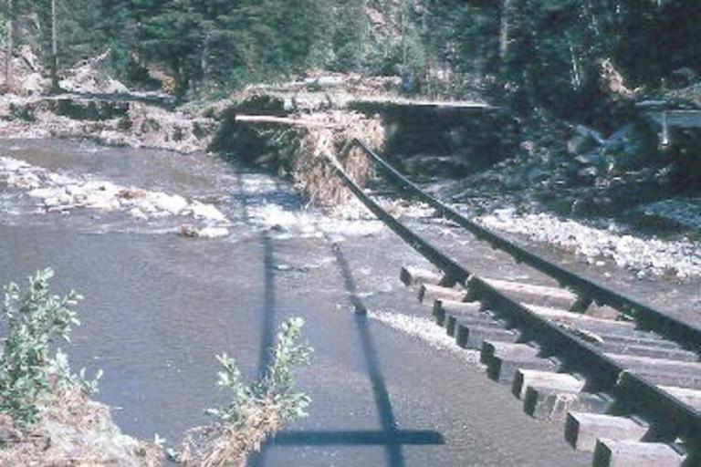
| Keywords: usgs flood flooding south dakota southdakota tbt throwbackthursday natural hazards naturalhazards bridge outdoor Watch Your Step — No, despite what it looks like this is not a practice course for Indiana Jones training for American Ninja Warrior. This is actually a shot from the aftermath of a devastating flood on June 9-10, 1972 Black Hills-Rapid City, SD flood of the Burlington-Northern Railroad west of Keystone, SD. Nearly 15 inches of rain fell in about 6 hours near Nemo, and more than 10 inches of rain fell over an area of 60 square miles. According to the Red Cross, the resulting floods left 238 people dead and 3,057 people injured. For more than 125 years, the USGS has monitored flow in selected streams and rivers across the U.S. The USGS collects data from more than 7,400 streamgages, many of which provide real-time data in 15-minute increments. The information is routinely used for water supply and management, monitoring floods and droughts, bridge and road design, determination of flood risk, and for many recreational activities. Read more about the flood at: on.doi.gov/SD1972Flood. Photo credits available on site. Watch Your Step — No, despite what it looks like this is not a practice course for Indiana Jones training for American Ninja Warrior. This is actually a shot from the aftermath of a devastating flood on June 9-10, 1972 Black Hills-Rapid City, SD flood of the Burlington-Northern Railroad west of Keystone, SD. Nearly 15 inches of rain fell in about 6 hours near Nemo, and more than 10 inches of rain fell over an area of 60 square miles. According to the Red Cross, the resulting floods left 238 people dead and 3,057 people injured. For more than 125 years, the USGS has monitored flow in selected streams and rivers across the U.S. The USGS collects data from more than 7,400 streamgages, many of which provide real-time data in 15-minute increments. The information is routinely used for water supply and management, monitoring floods and droughts, bridge and road design, determination of flood risk, and for many recreational activities. Read more about the flood at: on.doi.gov/SD1972Flood. Photo credits available on site. | ||||