MAKE A MEME
View Large Image

| View Original: | Vojvodina-1849-1860-2C.png (724x760) | |||
| Download: | Original | Medium | Small | Thumb |
| Courtesy of: | commons.wikimedia.org | More Like This | ||
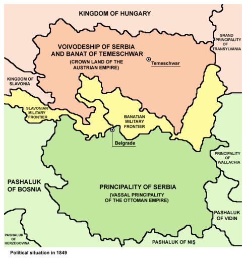
| Keywords: Vojvodina-1849-1860-2C.png en Two autonomous historical territories named Serbia 1 Principality of Serbia within Ottoman Empire 1833-1878 and 2 Voivodeship of Serbia and Banat of Temeschwar within Austrian Empire 1849-1860 sr ąöą▓ąĄ ą░čāč鹊ąĮąŠą╝ąĮąĄ ąĖčüčéąŠč ąĖčśčüą║ąĄ čéąĄč ąĖčéąŠč ąĖčśąĄ čüą░ ąĮą░ąĘąĖą▓ąŠą╝ ąĪč ą▒ąĖčśą░ 1 ąÜąĮąĄąČąĄą▓ąĖąĮą░ ąĪč ą▒ąĖčśą░ čā ąŠą║ą▓ąĖč čā ą×č鹊ą╝ą░ąĮčüą║ąŠą│ čåą░č čüčéą▓ą░ 1833-1878 ąĖ 2 ąÆąŠčśą▓ąŠą┤čüčéą▓ąŠ ąĪč ą▒ąĖčśą░ ąĖ ąóą░ą╝ąĖčłą║ąĖ ąæą░ąĮą░čé čā ąŠą║ą▓ąĖč čā ąÉčāčüčéč ąĖčśčüą║ąŠą│ čåą░č čüčéą▓ą░ 1849-1860 2007-02-22 own - created from this file http //commons wikimedia org/wiki/Image Serbia02 png author of that file was <font color blue >PANONIAN</font> - file was originally released by PANONIAN under PD-user licence PANONIAN May 2007 <font color red >Imbris</font> author of modified file version GFDL relicense Original upload log en wikipedia For the Common Good page en wikipedia Vojvodina-1849-1860-2C png wikitable - 23 15 3 February 2011 522 ├Ś 557 26 389 bytes Magog the Ogre w en <nowiki> Reverted to version as of 02 28 22 February 2007 - newer version on commons </nowiki> - 03 56 2 March 2007 522 ├Ś 557 24 204 bytes Imbris w en <nowiki> Summary <font color blue >PANONIAN</font> created http //commons wikimedia org/wiki/Image Serbia02 png under the <font color blue >PANONIAN</font> license <font color red </nowiki> - 02 28 22 February 2007 522 ├Ś 557 26 389 bytes Imbris w en <nowiki> User PANONIAN <font color blue >PANONIAN</font> created http //commons wikimedia org/wiki/Image Serbia02 png under the PD-user license <font color red >Imbris</font modified the object and renamed it to show a neutra </nowiki> Voivodeship of Serbia and Banat of Temeschwar Serbia18495 Maps of the Principality of Serbia Serbia18495 Habsburg Military Frontier Serbia18495 Maps of the Ottoman period in the history of Serbia Serbia18495 Maps of the Habsburg period in the history of Serbia Serbia18495 Maps of the history of Serbia in modern times Serbia18495 Maps of the history of Vojvodina Serbia18495 Maps of the Austrian Empire Serbia18495 Maps of vassal states of the Ottoman Empire Serbia18495 | ||||