MAKE A MEME
View Large Image

| View Original: | View towards Brighton City Centre from Canfield Close, near Coombe Road (July 2010).JPG (2400x1400) | |||
| Download: | Original | Medium | Small | Thumb |
| Courtesy of: | commons.wikimedia.org | More Like This | ||
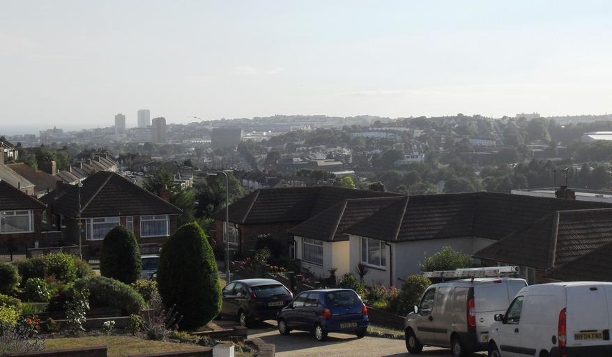
| Keywords: View towards Brighton City Centre from Canfield Close, near Coombe Road (July 2010).JPG Views of Brighton and Hove 4 This view looks southwestwards from Canfield Close a residential cul-de-sac on the east side of the Lewes Road valley in the Bear Road area of Brighton Although it is 2 5 mi km from the city centre this location provides an excellent view of it because of its elevation and open outlook Features click to enlarge The two tall tower blocks on the horizon are Chartwell Court 50 822712 -0 146976 and Sussex Heights 50 828873 0 138286 The sea can be seen behind and to the left of them The tall block which appears immediately in front of them is actually a long way inland it is Theobald House 50 828873 -0 138286 on Blackman Street next to Brighton station To the left of Chartwell Court the church spire belongs to St Paul's Church West Street 50 822038 -0 144649 The bulky building behind it is the Odeon Cinema 50 822038 -0 144649 The tall church below the seagull is St Bartholomew's Church 50 830872 -0 137072 in the New England Quarter The long straight road in front of it is Upper Lewes Road This leads to the Lewes Road Sainsbury's 50 837103 -0 125695 which is the wide building in the very centre of the picture Above this is the roof of Brighton station 50 830167 -0 141262 and behind this are the houses of West Hill Between the station and St Bartholomew's Church are the new buildings of the New England Quarter The curving streets to the right of the station are in Round Hill 50 841225 -0 115744 own 2010-07-31 The Voice of Hassocks Views of Brighton and Hove July 2010 in England Clickable images Bear Road area Brighton Cc-zero ImageNote 1 168 489 93 45 2400 1400 2 Spire of St Paul's Church West Street ImageNoteEnd 1 ImageNote 2 441 441 60 72 2400 1400 2 Chartwell Court ImageNoteEnd 2 ImageNote 3 537 420 54 87 2400 1400 2 Sussex Heights ImageNoteEnd 3 ImageNote 4 831 501 129 69 2400 1400 2 St Bartholomew's Church Ann Street ImageNoteEnd 4 ImageNote 5 1101 480 126 45 2400 1400 2 Brighton station ImageNoteEnd 5 ImageNote 6 1062 624 306 78 2400 1400 2 Sainsbury's Lewes Road built on the site of the viaduct carrying the Kemp Town branch line ImageNoteEnd 6 ImageNote 7 2277 501 120 69 2400 1400 2 Veolia refuse disposal facility Hollingdean Lane ImageNoteEnd 7 Clickable version <imagemap> Image View towards Brighton City Centre from Canfield Close near Coombe Road July 2010 JPG Parts of this image can be clicked to go to the relevant Wikipedia article rect 446 442 496 505 Chartwell Court rect 532 419 592 506 Sussex Heights rect 820 497 956 591 St Bartholomew's Church rect 1109 485 1227 516 Brighton station poly 1110 554 1457 490 1678 505 1680 651 1375 652 1159 644 Round Hill desc bottom-left </imagemap> | ||||