MAKE A MEME
View Large Image
| View Original: | US395 NSC Map.jpg (1394x1394) | |||
| Download: | Original | Medium | Small | Thumb |
| Courtesy of: | commons.wikimedia.org | More Like This | ||
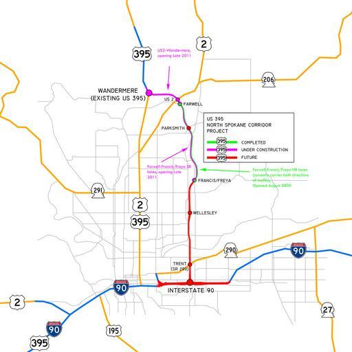
| Keywords: US395 NSC Map.jpg road map Map of the approved route of the US 395 North Spokane Corridor with surrounding context Transferred from http //en wikipedia org en wikipedia; transferred to Commons by User Jay8g using http //tools wikimedia de/~magnus/commonshelper php CommonsHelper <br/> Original text I Jdubman talk created this work entirely by myself used Image Washington State Route 290 svg Image US 395 svg Image US 2 svg Image US 195 svg Image WA-290 svg Image WA-291 svg Image WA-27 svg and Image I-90 big svg 10 02 8 January 2010 UTC <br/> 2010 01 08 first version ; 2010 05 30 last version Jdubman talk Original uploader was Jdubman at http //en wikipedia org en wikipedia Released into the public domain by the author en wikipedia Jdubman Original upload log page en wikipedia US395_NSC_Map jpg 2010-05-30 21 19 Jdubman 1394×1394× 212318 bytes <nowiki>Updated map to reflect opening and additional construction </nowiki> 2010-01-08 10 02 Jdubman 1000×1000× 115180 bytes <nowiki> Map of the approved route of the US 395 North Spokane Corridor with surrounding context I ~~~ created this work entirely by myself used Image Washington State Route 290 svg Image US 3</nowiki> State highways in Washington state Spokane Washington Maps of Spokane County Washington Road maps of Washington state North Spokane Corridor | ||||