MAKE A MEME
View Large Image
| View Original: | Uitsnede_Lepelenburg_uit_Traiectum_-_Wttecht_-_Utrecht_(Atlas_van_Loon).jpg (266x436) | |||
| Download: | Original | Medium | Small | Thumb |
| Courtesy of: | commons.wikimedia.org | More Like This | ||
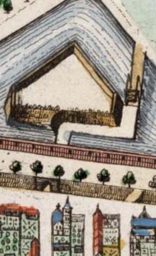
| Keywords: Uitsnede Lepelenburg uit Traiectum - Wttecht - Utrecht (Atlas van Loon).jpg nl Uitsnede uit een 17e eeuwse kaart Atlas van Loon 1649 van de stad Utrecht Erop staan bolwerk Lepelenburg huis Lepelenburg de Maliebrug en Maliepoort en de verdedigingsgracht Maliesingel Noot het oosten ligt boven in de afbeelding/kaart Traiectum_-_Wttecht_-_Utrecht_ Atlas_van_Loon jpg 1649 Traiectum_-_Wttecht_-_Utrecht_ Atlas_van_Loon jpg unknown derivative work Sonty567 <span class signature-talk >talk</span> took detail out Lepelenburg Sonty567 Traiectum_-_Wttecht_-_Utrecht_ Atlas_van_Loon jpg PD-old-100 Original upload log This image is a derivative work of the following images File Traiectum_-_Wttecht_-_Utrecht_ Atlas_van_Loon jpg licensed with Cc-pd-mark-footer PD-old 2009-10-21T22 34 25Z Kweniston 5274x4085 8484823 Bytes <nowiki> en Map of Utrecht Atlas van Loon author 1649 Old maps of Utrecht city Atlas van Loon</nowiki> Uploaded with derivativeFX Atlas van Loon Old maps of Utrecht city 1649 Maliebaan Stadsbuitengracht City gates in Utrecht city Maliebrug Utrecht in the 17th century | ||||
.jpg)