MAKE A MEME
View Large Image

| View Original: | Tsunami map Tohoku2011jp.svg (1128x942) | |||
| Download: | Original | Medium | Small | Thumb |
| Courtesy of: | commons.wikimedia.org | More Like This | ||
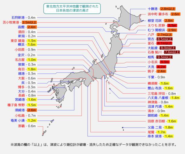
| Keywords: Tsunami map Tohoku2011jp.svg en Map of 2011 Tohoku Sendai earthquake observed tsunami heights in Japan ja ж ±еМЧе ∞жֺ姙еє≥жіЛж≤Це ∞й ЗгБІи¶≥жЄђгБХгВМгБЯг БжЧ•ж ђеРДе ∞гБЃжі•ж≥ҐгБЃйЂШгБХ JMAhttp //www jma go jp/jp/tsunami/observation_04_20110313180559 html 1 http //www jma go jp/jma/press/1103/14c/tsunami_onahama html 2 http //www jma go jp/jma/press/1103/23b/tsunami_miyako_ofunato html 3 http //www jma go jp/jma/press/1103/29c/201103291900 html 4 Eastwind41 2013-06-24 English version translatable <br>120px Information field Additional information гБУгБЃгГХгВ°гВ§гГЂгБѓ File 2011 Tohoku earthquake observed tsunami heights pngгБЃжГЕ冱гВТеЕГгБЂеЖНгГЗгВґгВ§гГ≥гГїSVGеМЦгБЧгБЯгВВгБЃгБІгБЩг В Created with Inkscape Valid SVG Maps and diagrams of the 2011 T≈Нhoku earthquake | ||||