MAKE A MEME
View Large Image
| View Original: | TravisCountyDistricts.png (1117x622) | |||
| Download: | Original | Medium | Small | Thumb |
| Courtesy of: | commons.wikimedia.org | More Like This | ||
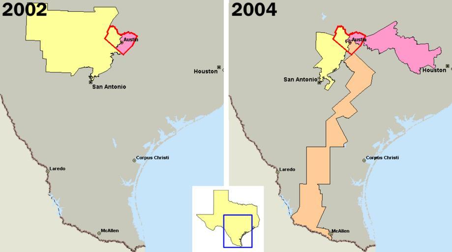
| Keywords: TravisCountyDistricts.png U S congressional districts covering en Travis County Texas outlined in red in 2002 left and 2004 In 2003 Republicans in the Texas legislature redistricted the state diluting the voting power of the heavily Democratic county by parceling its residents out to more Republican districts Created by me using Microsoft MapPoint 2004 and data from http //nationalatlas gov The district in orange is the infamous Fajita strip district 25 intended as a Democratic district while the other two districts 10 and 21 are intended to elect Republicans District 25 has now been redrawn as a result of the 2006 U S Supreme Court decision and is no longer a Fajita strip PHenry en wikipedia 2005-09-29 PHenry wikipedia en PHenry original upload log page en wikipedia TravisCountyDistricts png 2005-09-29 03 58 PHenry 1117×622×8 25178 bytes <nowiki>Created by me using Microsoft MapPoint 2004 and data from http //nationalatlas gov</nowiki> Politics of the United States Congressional district maps of Texas Travis County Texas | ||||