MAKE A MEME
View Large Image
| View Original: | The_Quarterly_journal_of_the_Geological_Society_of_London_(13935661031).jpg (1170x2049) | |||
| Download: | Original | Medium | Small | Thumb |
| Courtesy of: | commons.wikimedia.org | More Like This | ||
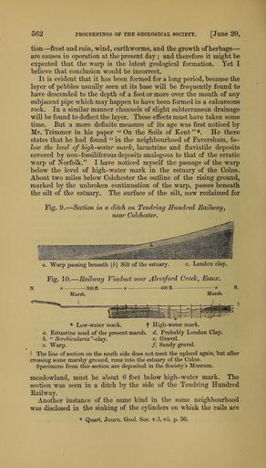
| Keywords: The Quarterly journal of the Geological Society of London (13935661031).jpg 562 <br> PROCEEDINGS OF THE GEOLOGICAL SOCIETY Juiie 20 <br> tion ” frost and rain wind earthworms and the growth of herbage ” – <br> are causes in operation at the present day ; and therefore it might be <br> expected that the warp is the latest geological formation Yet I <br> believe that conclusion would be incorrect <br> It is evident that it has been formed for a long period because the <br> layer of pebbles usually seen at its base vrill be frequently found to <br> have descended to the depth of a foot or more over the mouth of any <br> subjacent pipe which may happen to have been formed in a calcareous <br> rock In a similar manner channels of slight subterranean drainage <br> will be found to deflect the layer These effects must have taken some <br> time But a more definite measure of its age was first noticed by <br> Mr Trimmer in his paper On the Soils of Kent He there <br> states that he had found in the neighbourhood of Taversham he- <br> low the level of high-water mark lacustrine and fluviatile deposits <br> covered by non-fossHiferous deposits analogous to that of the erratic <br> warp of Norfolk I have noticed myself the passage of the warp <br> below the level of high-water mark in the estuary of the Colne <br> About two miles below Colchester the outline of the rising ground <br> marked by the unbroken continuation of the warp passes beneath <br> the silt of the estuary The surface of the silt now reclaimed for <br> Fig 9 - <br> Section in a ditch on Tendring Hundred Railway j <br> near Colchester <br> a Warp passing beneath 6 Silt of the estuary c London clay <br> Fig 10 ” Railway Viaduct over Alresford Creek Essex <br> X 300 ft X 400 ft <br> Marsh <br> X <br> Marsh <br> Low- water mark <br> a Estuarine mud of the present marsh <br> b Scrobicularia -clsij <br> c Warp <br> t High-water mark <br> d Probably London Clay <br> e Gravel <br> / Sandy gravel <br> The line of section on the south side does not meet the upland again but after <br> crossing some marshy ground runs into the estuary of the Colne <br> Specimens from this section are deposited in the Society's Museum <br> meadowland must be about 6 feet below high-water mark The <br> section was seen in a ditch by the side of the Tendring Hundred <br> E-ailway <br> Another instance of the same kind in the same neighbourhood <br> was disclosed in the sinking of the cyHnders on which the rails are <br> Quart Journ Geol Soc vjI vii p 36 36165015 111477 51125 Page 562 Text v 22 http //www biodiversitylibrary org/page/36165015 1866 Geological Society of London Biodiversity Heritage Library The Quarterly journal of the Geological Society of London v 22 1866 Geology Periodicals Smithsonian Libraries bhl page 36165015 dc identifier http //biodiversitylibrary org/page/36165015 smithsonian libraries Information field Flickr posted date ISOdate 2014-04-21 Check categories 2015 August 26 CC-BY-2 0 BioDivLibrary https //flickr com/photos/61021753 N02/13935661031 2015-08-26 06 54 32 cc-by-2 0 PD-old-70-1923 The Quarterly journal of the Geological Society of London 1866 Photos uploaded from Flickr by Fæ using a script | ||||
.jpg)