MAKE A MEME
View Large Image

| View Original: | Stockholm county 1200-BC.svg (874x1149) | |||
| Download: | Original | Medium | Small | Thumb |
| Courtesy of: | commons.wikimedia.org | More Like This | ||
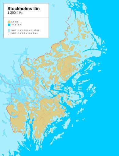
| Keywords: Stockholm county 1200-BC.svg en The Stockholm area around 1200 years BC 3200 BP The extent of land at the time yellow was smaller than today with water blue tones covering areas that are above the shoreline today Present-day shorelines county and municipality borders shown for comparison The map shows post-glacial rebound and shoreline displacement in present-day Stockholm county sv Stockholmsområdet omkring 1 200 år f Kr 3 200 år före nutid Landytorna gult var begränsade jämfört med idag Vatten blåa nyanser täckte områden som idag ligger över havsytan till följd av av landhöjningen Samtida strandlinjer samt läns- och kommungränser visas för jämförelse Own work by uploader + Online map creation; data from http //www lansmuseum a se/ Stockholms länsmuseum Koyos 2009-05-25 <gallery> File Stockholm county 5000-BC svg Stockholm county 5000 BC Swedish Vector version svg File Stockholm county 5000-BC png Stockholm county 5000 BC Swedish Bitmap version png </gallery> <gallery> File Stockholm county 3000-BC svg Stockholm county 3000 BC Swedish Vector version svg File Stockholm county 3000-BC png Stockholm county 3000 BC Swedish Bitmap version png </gallery> <gallery> File Stockholm county 1200-BC svg Stockholm county 1200 BC Swedish Vector version svg File Stockholm county 1200-BC png Stockholm county 1200 BC Swedish Bitmap version png </gallery> Post-glacial rebound History of the Baltic Sea Stockholm -8800 History of Stockholm -8800 Maps of the history of Sweden Stockholm -8800 Quaternary in Europe | ||||