MAKE A MEME
View Large Image
| View Original: | Stockdale_A_plan_of_the_city_of_Berlin_1800_(1748).jpg (4845x3570) | |||
| Download: | Original | Medium | Small | Thumb |
| Courtesy of: | commons.wikimedia.org | More Like This | ||
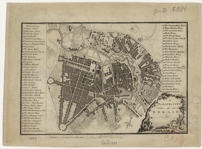
| Keywords: Stockdale A plan of the city of Berlin 1800 (1748).jpg InteractiveViewer A plan of the city of Berlin Published by J Stockdale Format 25 3 x 18 0 cm 17 6 x 16 7 cm n d Plan Maßstab 1 20 300 Orientierung Nord Kupferstich sw kol Die Karte erschien zuerst 1772 in London und wurde dann 1800 nochmals neu aufgelegt Es handelt sich um eine verkleinerte Kopie des Stadtplans von Schmettau von dem in der zweiten Hälfte des 18 Jahrhunderts noch zahlreiche andere Kopien im Ausland erschienen Der Plan zeigt somit immer noch den Stand des Schmettauschen Plans von 1748 u a noch mit der Bastionierung der Museumsinsel Als historische Quelle ist der Plan daher eher uninteressant - allerdings bemerkenswert wie lang der Plan nach Schmettau noch weiterhin kopiert und vertrieben wurde Bibliothèque nationale de France - Gallica http //gallica bnf fr/ark /12148/btv1b84449208 btv1b84449208 published 1800 copy of a map from 1748 Hrsg John Stockdale copy from Schmettau PD-old-70-1923 1748 in Berlin Old maps of Berlin 1800 | ||||
.jpg)