MAKE A MEME
View Large Image

| View Original: | Spanish trade routes across the isthmus of Panama.svg (730x730) | |||
| Download: | Original | Medium | Small | Thumb |
| Courtesy of: | commons.wikimedia.org | More Like This | ||
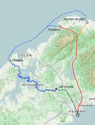
| Keywords: Spanish trade routes across the isthmus of Panama.svg Thumbnail with colored legend in caption thumb 300px Spanish trade routes across the isthmus of Panama<br /> <span style color FF0000 > –¬ –¬ –¬</span> Camino Real Portobelo to Panama <br /> <span style color FF9900 > –¬ –¬ –¬</span> Camino Real Nombre de Dios branch <br /> <span style color 0000FF > –¬ –¬ –¬</span> Las Cruces Trail Chagres River leg <br /> <span style color 006666 > –¬ –¬ –¬</span> Las Cruces Trail overland leg en Spanish trade routes across the isthmus of Panama Legend <span style color FF0000 > –¬ –¬ –¬</span> Camino Real Portobelo to Panama <span style color FF9900 > –¬ –¬ –¬</span> Camino Real Nombre de Dios branch <span style color 0000FF > –¬ –¬ –¬</span> Las Cruces Trail Chagres River leg <span style color 006666 > –¬ –¬ –¬</span> Las Cruces Trail overland leg http //sharemap org/public/Spanish_trade_routes_across_the_isthmus_of_Panama Geospatial data sources <a href http //wiki openstreetmap org/wiki/OpenStreetMap_License >Open Street Map Data</a> CC-SA-BY <a href http //www bts gov/publications/north_american_transportation_atlas_data/ >NORTAD</a> public domain <a href http //www naturalearthdata com/ >Natural Earth</a> public domain Trail river line lines Kaart van de Landengte van Panama Isaak Tirion Amsterdam ca 1745 thumb left Panama-canal-shepherd-map Matjamoe 2012-12-18 Other fields O + ShareMap org Maps Created with ShareMap Maps of the history of Panama cc-by-sa-3 0 GFDL redundant | ||||