MAKE A MEME
View Large Image
| View Original: | South Coast Rail map.svg (4700x3200) | |||
| Download: | Original | Medium | Small | Thumb |
| Courtesy of: | commons.wikimedia.org | More Like This | ||
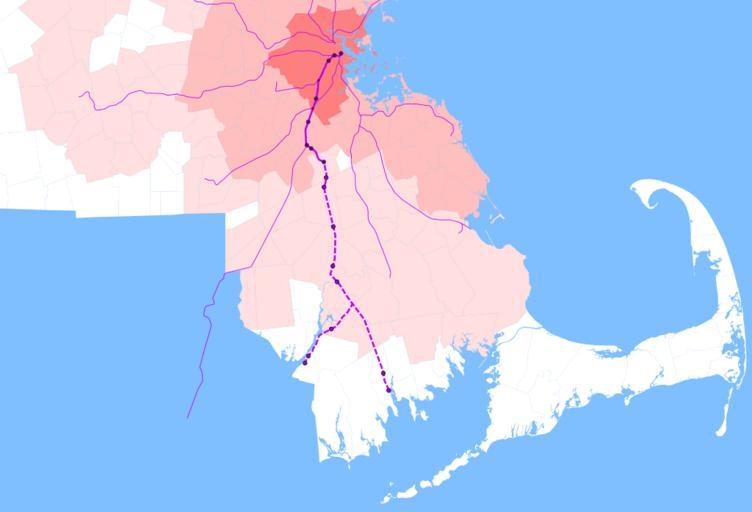
| Keywords: South Coast Rail map.svg Map of the proposed South Coast Rail project Existing Stoughton Line is the solid thick line; South Coast Rail is thick and dashed Other Commuter Rail lines are thin Large dark dots are current Stoughton Line stations smaller dots are stations along the line not served by Stoughton trains and lighter dots are proposed SCR stations Towns are shaded by entry into the MBTA district Old MTA district darkest then original MBTA district then 1999 expansion Martha's Vineyard and Nantucket are not shown Data source http //www mass gov/mgis/download htm Office of Geographic and Environmental Information MassGIS Commonwealth of Massachusetts Executive Office of Environmental Affairs Mbta_district svg 2011-07-26 01 19 UTC Mbta_district svg User SPUI derivative work Pi 1415926535 <span class signature-talk >talk</span> Cropping lines converted to paths emphasize SCR Pi 1415926535 Mbta_district svg MBTA district Old MTA district darkest then original MBTA district then 1999 expansion Commuter Rail lines in purple planned lines thinner and dashed Data source http //www mass gov/mgis/download htm Offi</nowiki> Uploaded with derivativeFX Maps of MBTA Commuter Rail South Coast Rail Maps by User Pi 1415926535 MBTA in 2012 | ||||