MAKE A MEME
View Large Image

| View Original: | Slavo serbia location map-sr.png (1573x2176) | |||
| Download: | Original | Medium | Small | Thumb |
| Courtesy of: | commons.wikimedia.org | More Like This | ||
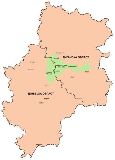
| Keywords: Slavo serbia location map-sr.png en Borders of historical Slavo-Serbia 1753-1764 compared with borders of modern Luhansk Oblast and Donetsk Oblast of Ukraine sr –ď— –į–Ĺ–ł—Ü–Ķ –ł—Ā—ā–ĺ— –ł—ė—Ā–ļ–Ķ –°–Ľ–į–≤–Ķ–Ĺ–ĺ—Ā— –Ī–ł—ė–Ķ 1753-1764 —É–Ņ–ĺ— –Ķ—í–Ķ–Ĺ–Ķ —Ā–į –≥— –į–Ĺ–ł—Ü–į–ľ–į –ī–į–Ĺ–į—ą—ö–Ķ –õ—É–≥–į–Ĺ—Ā–ļ–Ķ –ĺ–Ī–Ľ–į—Ā—ā–ł –ł –Ē–ĺ—ö–Ķ—Ü–ļ–Ķ –ĺ–Ī–Ľ–į—Ā—ā–ł —É –£–ļ— –į—ė–ł–Ĺ–ł own PANONIAN 2014 Cc-zero References Mita Kostińá Nova Srbija i Slavenosrbija Novi Sad 2001 Olga M Posunjko Istorija Nove Srbije i Slavenosrbije Novi Sad 2002 Pavel Rudjakov Seoba Srba u Rusiju u 18 veku Beograd 1995 http //www rastko rs/rastko-ukr/istorija/img/sloveno_serbija jpg http //www irekw internetdsl pl/27_1727-1768 jpg http //www jewishgen org/Ukraine/maps/Ukrainian-Land-1750 jpg http //ua all-biz info/img/regions/pic/25_16_radm_955383044 gif http //ukrgr net/files/images/luganskaja-02 gif http //ukrindustrial com/img/regions/pic/24_16_radm_358268491 gif http //www rada gov ua/~dtrp/data/obl/don jpg Maps of Slavo-Serbia Maps of Luhansk Oblast Maps of the history of Donetsk Oblast Maps in Serbian | ||||