MAKE A MEME
View Large Image
| View Original: | Seattle_uplift_17D.png (424x200) | |||
| Download: | Original | Medium | Small | Thumb |
| Courtesy of: | commons.wikimedia.org | More Like This | ||
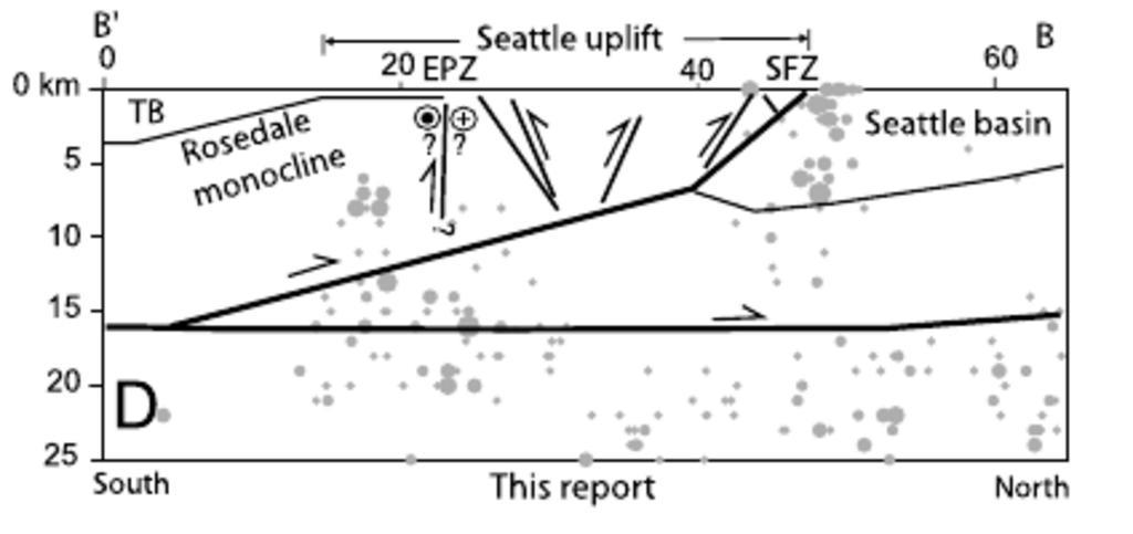
| Keywords: Seattle uplift 17D.png en One model of the Seattle Uplift Cross-section along the east side of central Puget Sound looking west TB Tacoma Basin EPZ East Passage Zone Maury Island SFZ Seattle Fault Zone Alki Point Grey dots are hypocenters of earthquakes of magnitude 2 or more for 1970 2001 Circles over question marks indicate hypothesized left-lateral strike-slip left-side is approaching http //earthquake usgs gov/regional/pacnw/ships/pdfs/JohnsonTectonics2004 pdf Authors are all USGS staff; paper carries statement that it is not subject to U S copyright From an article dated 2004 PD-USGov-USGS Figure 17D from Johnson et al 2004 Active shortening of the Cascadia forearc and implications for seismic hazards of the Puget Lowland Tectonics vol 23 TC1011 2004 PD-USGov Faults in Washington state Geology of Washington state Geological cross sections of the United States | ||||