MAKE A MEME
View Large Image
| View Original: | San_Francisco,_California,_1899,_15-minute_topographic_map.png (1201x851) | |||
| Download: | Original | Medium | Small | Thumb |
| Courtesy of: | www.flickr.com | More Like This | ||
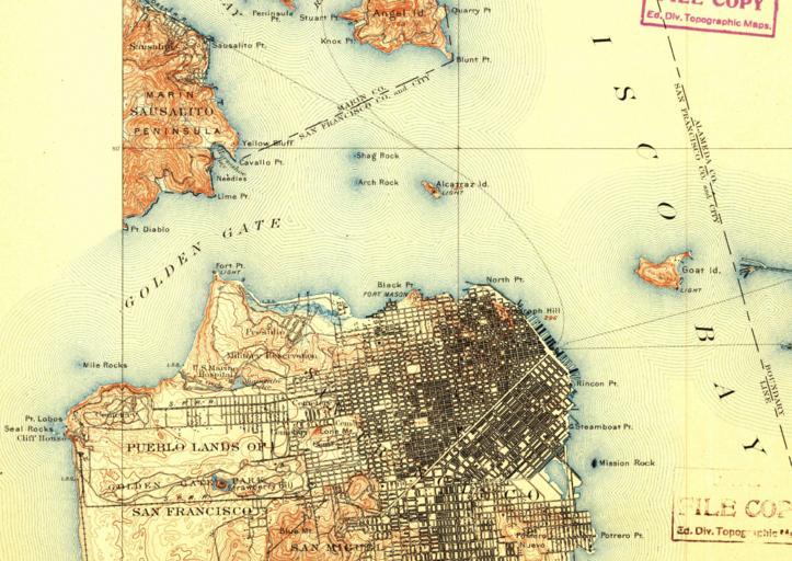
| Keywords: topographic map historical san francisco sanfrancisco usgs store usgsstore golden gate bridge goldengatebridge drawing We have clipped a portion of the 1899 topographic map covering the San Francisco Bay Area -- notice the missing iconic bridge that now graces many a tourist's picture of this famous city's skyline. When this map was created travelers between San Francisco and Marin County had only ferry service to take them across the Golden Gate Strait. Did you know that you can now download and view the entire U.S. Geological Survey Historical Topographic Map Collection? By simply using the Map Locator and Downloader on the USGS Store at store.usgs.gov anyone can access historical maps of their home towns, or anywhere in the United States with a click of a mouse. Historical maps can be the last piece of the puzzle in genealogy research. What did the landscape look like decades ago when your ancestors settled in your town? How have place names, roads, and streams changed over time? Although technically out of date, these historical maps are often helpful to those researching a specific geographic location, such as genealogists, scientists, and environmentalists. Go ahead and give it a try and find historical topographic maps that speak to you. We have clipped a portion of the 1899 topographic map covering the San Francisco Bay Area -- notice the missing iconic bridge that now graces many a tourist's picture of this famous city's skyline. When this map was created travelers between San Francisco and Marin County had only ferry service to take them across the Golden Gate Strait. Did you know that you can now download and view the entire U.S. Geological Survey Historical Topographic Map Collection? By simply using the Map Locator and Downloader on the USGS Store at store.usgs.gov anyone can access historical maps of their home towns, or anywhere in the United States with a click of a mouse. Historical maps can be the last piece of the puzzle in genealogy research. What did the landscape look like decades ago when your ancestors settled in your town? How have place names, roads, and streams changed over time? Although technically out of date, these historical maps are often helpful to those researching a specific geographic location, such as genealogists, scientists, and environmentalists. Go ahead and give it a try and find historical topographic maps that speak to you. | ||||