MAKE A MEME
View Large Image
| View Original: | Roman_Roads_of_Britain_-_Matthew_Paris,_Book_of_Additions_(c.1250),_f._187v.jpg (515x712) | |||
| Download: | Original | Medium | Small | Thumb |
| Courtesy of: | commons.wikimedia.org | More Like This | ||
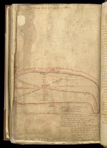
| Keywords: Roman Roads of Britain - Matthew Paris, Book of Additions (c.1250), f. 187v.jpg Ermine Street Fosse Way Watling Street and Ickneild Way as identified by Henry of Huntingdon c 1130 and specified in the so-called Leges Edwardi Confessoris c 1140 <br/> The map is orientated with West at the top North to the right In the middle of the map is Dunstable where there was a cell of the Abbey of St Albans through which roads cross from Salisbury to Bury St Edmunds Ickneild Way Dover to Chester Watling Street Ermine Street running South to North and the Fosse Way shown running from Exeter to Caithness <p>Further reading O Roucoux The Roman Watling Street from London to High Cross Dunstable Museum Trust 1984; pp 62 “63 page http //ogimages bl uk/images/011/011COTNERD00001U00187V00 5BSVC2 5D jpg image creator Matthew Paris PD-old-100 Uploaded with UploadWizard Maps by Matthew Paris Old maps of Great Britain 1250 E Matthew Paris Liber Additamentorum 13th-14th C - BL Cotton MS Nero D I | ||||
,_f._187v.jpg)