MAKE A MEME
View Large Image
| View Original: | Roanoke_map_1584.JPG (648x1323) | |||
| Download: | Original | Medium | Small | Thumb |
| Courtesy of: | commons.wikimedia.org | More Like This | ||
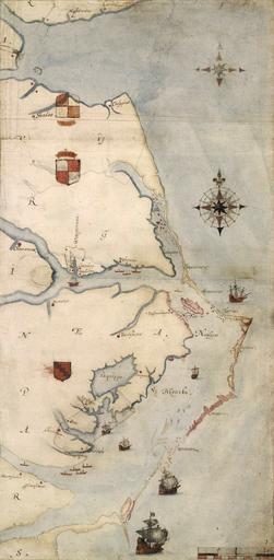
| Keywords: Roanoke map 1584.JPG 1585 map of the east coast of North America from the Chesapeake Bay to Cape Lookout by John White Een kaart van het Roanoke-gebied door John White A British Museum photograph of the map http //www britishmuseum org/research/collection_online/collection_object_details/collection_image_gallery aspx assetId 26038 objectId 753203 partId 1 1585-1593 John White cropped and slight levels adjustment earthsound PD-Art PD-old-100 1593 Old maps of the United States Maps of the history of the United States 1585 maps John White Roanoke Colony Maps of North Carolina | ||||