MAKE A MEME
View Large Image
| View Original: | Region system8.png (2480x3372) | |||
| Download: | Original | Medium | Small | Thumb |
| Courtesy of: | commons.wikimedia.org | More Like This | ||
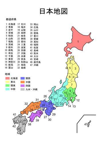
| Keywords: Region system8.png Map of Japan with prefectures named and colour-coded by region Originally from English Wikipedia 2007-02-07 Montydrei File summary from English Wikipedia Created by myself using Inkscape and existing prefectural maps on Wikipedia File history from English Wikipedia del cur 06 00 7 February 2007 Montydrei Talk contribs 2480×3372 466 664 bytes extremely minor edit of 富山 to match anti-aliasing of other prefecture names del rev 07 28 8 January 2007 Montydrei Talk contribs 2480×3372 466 468 bytes used Fg2's image and compressed the filesize using pngcrush del rev 13 24 3 January 2007 Fg2 Talk contribs 2480×3372 621 066 bytes I modified the original by Montydrei changing 16 from Fukuyama 福山 to Toyama 富山 Montydrei assigned the original to the public domain and I assign my modifications to the public domain del rev 14 04 3 October 2006 Montydrei Talk contribs 2480×3372 467 058 bytes Created myself using Inkscape Maps of prefectures of Japan Regions of Japan Maps in Japanese | ||||