MAKE A MEME
View Large Image

| View Original: | Rb-map.png (328x352) | |||
| Download: | Original | Medium | Small | Thumb |
| Courtesy of: | commons.wikimedia.org | More Like This | ||
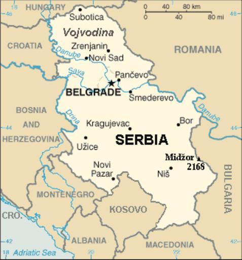
| Keywords: Rb-map.png Map of the Republic of Serbia FIPS 10 country code standard RB https //www cia gov/library/publications/the-world-factbook/geos/rb html The World Factbook published by CIA in 2008 2008-02-28 Central Intelligence Agency of the Government of the United States of America PD-USGov-CIA-WF Recommend that Image Sr-map png should be deleted and Image Serbia-CIA WFB Map png should be spared to show how the map looked before 2008 Map of Serbia from https //www cia gov/library/publications/the-world-factbook/geos/rb html The World Factbook published by CIA in 2008 This map is updated with current events; independence of Kosovo and certain faults like BUL is replaced with BULGARIA The name of the country is in bold font like the name of the Autonomous Province of Vojvodina Northern Serbian province Also the highest mountain in Serbia Central Serbia region is marked at the border with Bulgaria with the name of that peak - Midžor - and added the height in meters The name of the file The National Geospatial-Intelligence Agency maintains the FIPS 10 country code standard that US Government use On 2006-07-11 the following changes have been made DELETE the following geopolitical entities and codes YI SERBIA AND MONTENEGRO YI01 Crna Gora Montenegro YI02 Srbija Serbia <hr> ADD the following geopolitical entity and code MJ MONTENEGRO ADD the following geopolitical entity and code RB SERBIA The notice was issued by Randall E Flynn<br> Geographer<br> National Geospatial-Intelligence Agency GEOnet Names Server at this http //earth-info nga mil/gns/html/index html web-site Recommend that Image Sr-map png should be deleted and Image Serbia-CIA WFB Map png should be spared to show how the map looked before 2008 PD-USGov-CIA-WF For enhancements Political maps of Serbia | ||||