MAKE A MEME
View Large Image
| View Original: | Quinsigamond_River_(Massachusetts)_map.jpg (2072x4772) | |||
| Download: | Original | Medium | Small | Thumb |
| Courtesy of: | commons.wikimedia.org | More Like This | ||
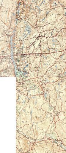
| Keywords: Quinsigamond River (Massachusetts) map.jpg Map of the Quinsigamond River and environs Massachusetts USA This image has been stitched together from three USGS 7 5 Minute Series maps unfortunately of different graphical styles though similar dates Worcester North MA Quadrangle 1939 ; Shrewsbury MA Quadrangle 1943 ; Grafton MA Quadrangle 1944 1939 1943 1944 United States Geological Survey US Department of the Interior Public domain - original work of the US Federal Government PD-USGov Quinsigamond River Shrewsbury Massachusetts | ||||
_map.jpg)