MAKE A MEME
View Large Image
| View Original: | Pub161-pgIV.jpg (770x950) | |||
| Download: | Original | Medium | Small | Thumb |
| Courtesy of: | commons.wikimedia.org | More Like This | ||
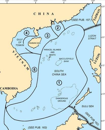
| Keywords: Pub161-pgIV.jpg Map of the w South China Sea region showing the areas covered by NGA Pub 161 Sailing Directions Enroute South China Sea and the Gulf of Thailand Fifteenth Edition 2014 Page IV of http //msi nga mil/MSISiteContent/StaticFiles/NAV_PUBS/SD/Pub161/Pub161bk pdf<br> Pub 161 Sailing Directions Enroute South China Sea and the Gulf of Thailand Fifteenth Edition 2014 corrected to 15 November 2014 2014-11-30 National Geospatial-Intelligence Agency NGA <br> under the authority of Department of Defense Directive 5105 40 dated 12 December 1988 and pursuant to the authority contained in U S Code Title 10 Sections 2791 and 2792 and Title 44 Section 1336 © COPYRIGHT 2014 BY THE UNITED STATES GOVERNMENT NO COPYRIGHT CLAIMED UNDER TITLE 17 U S C 100px File Pub161-pg1 jpg Maps of the Spratly Islands PD-USGov | ||||