MAKE A MEME
View Large Image
| View Original: | Provincetown_before_after_railroad.png (2230x2460) | |||
| Download: | Original | Medium | Small | Thumb |
| Courtesy of: | commons.wikimedia.org | More Like This | ||
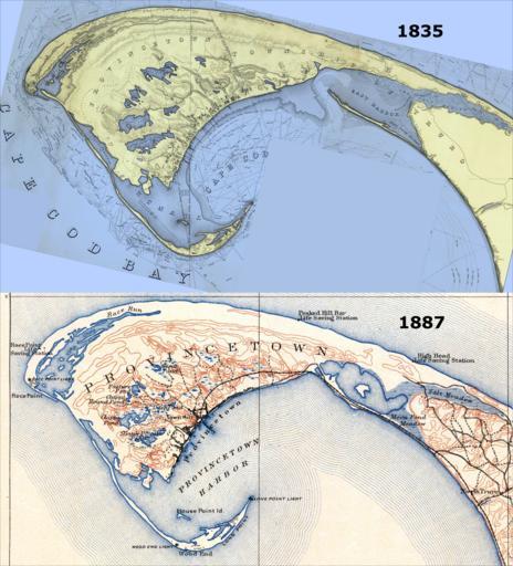
| Keywords: Provincetown before after railroad.png Town of Provincetown before and after the railroad Most notably there were no roads in/out of town until the US government artificially sealed off the Eastern Harbor This was done so as to prevent storm washout from breaching the northernmost part of that harbor; a breach would have made Provincetown an island permanently and would have destroyed the valuable harbor This later provided the foundation for the railroad to finally come to Provincetown in 1873 and for a formal road in 1877 Top 1835 map extracted from A Map Of The Extremity Of Cape Cod Including the Townships of Provincetown Truro A Chart Of Their Sea Coast And Of Cape Cod Harbour State of Massachusetts by the U S Topographical Engineers later were rolled into the US Army Corps of Engineers Grolltech Colorized and reoriented with north to top of page Bottom 1887 map extracted from Massachusetts Provincetown Sheet by the US Geological Survey See individual file pages for more details about the original works United States Topographical Bureau top US Geological Survey bottom 1835 top and 1887 bottom Top Graham Maj James D Hood Washington U S Topo Engrs United States Topographical Bureau Bottom Henry Gannett and Marcus Baker US Geological Survey USGS Grolltech PD-old-100 PD-USGov 1836 Provincetown US Topographical Bureau jpg 1889 USGS Provincetown png Maps of Provincetown Massachusetts Old maps of Massachusetts United States Geological Survey maps Before and after | ||||