MAKE A MEME
View Large Image

| View Original: | Prefecture of Illyricum map.png (1054x1041) | |||
| Download: | Original | Medium | Small | Thumb |
| Courtesy of: | commons.wikimedia.org | More Like This | ||
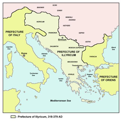
| Keywords: Prefecture of Illyricum map.png Historic map of Roman Praetorian Prefecture of Illyricum 318-379 AD Istorijska karta rimske pretorijanske prefekture Ilirik 318-379 godine РҳСҒСӮРҫС РёСҒРәР° РәР°С СӮР° РҪР° Р РёРјСҒРәР°СӮР° РҝС РөСӮРҫС РёСҒРәР° РҝС РөС„РөРәСӮСғС Р° РҳР»РёС РёРәСғРј РІРҫ РҝРөС РёРҫРҙРҫСӮ РҫРҙ 318-379 РіРҫРҙРёРҪР° Transferred from http //en wikipedia org en wikipedia en sr СлиРәР° Prefecture png 2005-12-06 Original uploader was PANONIAN at http //en wikipedia org en wikipedia Later version s were uploaded by Megistias at http //en wikipedia org en wikipedia Released into the public domain by the author self made map by user PANONIAN en wikipedia PANONIAN References The Times History of Europe Times Books London 2002 Dragan BrujiДҮ VodiДҚ kroz Svet antike Beograd 2005 Dragan BrujiДҮ VodiДҚ kroz Svet Vizantije Beograd 2004 Petar MiloЕЎeviДҮ Arheologija i istorija Sirmijuma Novi Sad 2001 http //sitemaker umich edu/mladjov/files/romanprefectures395s jpg http //www roman-empire net/maps/empire/extent/constantine html http //www newadvent org/cathen/07663a htm original upload log page en wikipedia Prefecture png 2008-01-03 12 02 Megistias 1054Г—1041Г—8 464015 bytes <nowiki>historic map self made Maps of the history of the Balkans Maps of the history of Vojvodina Maps of the history of Serbia sr СлиРәР° Prefecture png </nowiki> 2005-12-06 03 14 PANONIAN 1054Г—1041Г—8 464862 bytes <nowiki></nowiki> Praetorian prefecture of Illyricum Maps of the history of the ancient Balkans Maps of Roman provinces Maps of Europe in the 4th century Maps of the history of Vojvodina Maps of the history of Serbia in ancient times Maps of the history of Syrmia Maps of the history of Republika Srpska Maps of Illyricum Serbia in the 4th century Romania in the 4th century Maps of the history of Romania in ancient times | ||||