MAKE A MEME
View Large Image
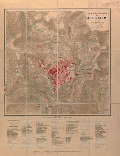
| View Original: | Plan_topographique_de_Jerusalem_et_de_ses_environs_-_dresse_en_1886_par_l'abbe_H._Nicole._Grave_et_imprime_par_Erhard_Fres_Paris.jpg (2100x2738) | |||
| Download: | Original | Medium | Small | Thumb |
| Courtesy of: | commons.wikimedia.org | More Like This | ||
| Keywords: Plan topographique de Jerusalem et de ses environs - dresse en 1886 par l'abbe H. Nicole. Grave et imprime par Erhard Fres Paris.jpg מפה ×©× ×™×¨×•×©× ×™× http //web nli org il/sites/NLI/Hebrew/digitallibrary/Laor-Collection/Pages/maps aspx en Topography of modern Jerusalem and its surroundings oriented to the north By Nicole 1886 he טופוגרפיה ×©× ×™×¨×•×©× ×™× ×”×ž×•×“×¨× ×™×ª וסביבותיה ×ž×›×•×•× ×ª × ×¦×¤×•×Ÿ × ×™×§×•× 1886 Dimensions 413x420 mm http //web nli org il/sites/NLI/Hebrew/digitallibrary/pages/viewer aspx presentorid NLI_MAPS_JER DocID NNL_MAPS_JER002368140 Click to enlarge http //web nli org il/sites/NLIS/en/Maps The Eran Laor Cartographic Collection National Library of Israel 2015-12-08 16 44 07 http //web nli org il/sites/NLI/English/Pages/default aspx The National Library of Israel PD-old Old maps of Jerusalem GLAM National Library of Israel Laor collection | ||||