MAKE A MEME
View Large Image
| View Original: | Plan_Nicholsona.jpg (6092x4849) | |||
| Download: | Original | Medium | Small | Thumb |
| Courtesy of: | commons.wikimedia.org | More Like This | ||
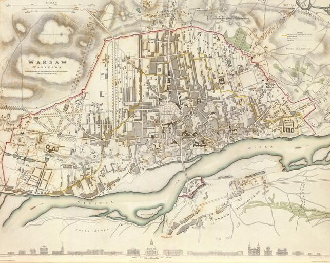
| Keywords: Plan Nicholsona.jpg Artwork Drawn by Creator William Barnard Clarke Engraved by en 1831 map of Warsaw Poland the so-called Nicholson's Plan Note that the map is neither very accurate in terms of precision http //194 29 130 173/users/s_piotrbaszynski/weblog/812eb/NICHOLSON_PLAN_1831 html nor in proper place names Many if not most have been misspelt Oyrod Krole park should be Ogród Królewski Kozary Wielopolski six buildings to the north of the park should be called Koszary Wielopolskie Cekauz Arsenal > Cekhauz Patac Kroleski > Pałac Królewski and so on Downloaded from David Rumsey's site http //www davidrumsey com/luna/servlet/detail/RUMSEY~8~1~21042~540019 Warsaw--Warszawa--Published-under-t sort Pub_List_No_InitialSort 2CPub_Date 2CPub_List_No 2CSeries_No qvq w4s /who/Nicholson +T +E ;q Warsaw;sort Pub_List_No_InitialSort 2CPub_Date 2CPub_List_No 2CSeries_No;lc RUMSEY~8~1 mi 0 trs 1 converted from sid to tiff format with mrsidgeodecode and then to jpg with Adobe PS pl Plan Warszawy z roku 1831 tzw Plan Nicholsona Plan jest względnie niedokładny zarówno jeśli chodzi o precyzję jak i nazwy własnehttp //194 29 130 173/users/s_piotrbaszynski/weblog/812eb/NICHOLSON_PLAN_1831 html Wiele z nich zostało przekręconych na przykład Oyrod Krole zamiast Ogród Królewski Kozary Wielopolski w miejsce Koszarów Wielopolskich Cekauz zamiast Cekhauz Patac Kroleski zamiast Pałac Królewski itd Mapa pobrana ze strony Davida Rumseya http //www davidrumsey com/luna/servlet/detail/RUMSEY~8~1~21042~540019 Warsaw--Warszawa--Published-under-t sort Pub_List_No_InitialSort 2CPub_Date 2CPub_List_No 2CSeries_No qvq w4s /who/Nicholson +T +E ;q Warsaw;sort Pub_List_No_InitialSort 2CPub_Date 2CPub_List_No 2CSeries_No;lc RUMSEY~8~1 mi 0 trs 1 przekonwertowana z formatu sid do tiff za pomocą mrsidgeodecode a następnie do formatu jpg z użyciem Adobe Photoshop 1831-11-01 engraving Size cm 38 30 object history exhibition history credit line Published under the superintendence of the Society for the Diffusion of Useful Knowledge Drawn by W B Clarke archt Engraved by T E Nicholson Published by Baldwin Cradock 47 Paternoster Row Novr 1 1831 London Chapman Hall 1844 accession number place of creation http //www davidrumsey com/luna/servlet/detail/RUMSEY~8~1~21042~540019 Warsaw--Warszawa- sort Pub_List_No_InitialSort 2CPub_Date 2CPub_List_No 2CSeries_No qvq w4s /where/Poland;q Warsaw;sort Pub_List_No_InitialSort 2CPub_Date 2CPub_List_No 2CSeries_No;lc RUMSEY~8~1 mi 8 trs 16 see below <gallery>File Warsaw-map-1831-closeup jpg</gallery> PD-old-100 Uploaded with UploadWizard Historical maps of Warsaw ImageNote 1 2993 2283 178 178 6092 4849 2 Saxon Palace ImageNoteEnd 1 ImageNote 2 3584 2607 218 121 6092 4849 2 Royal Castle ImageNoteEnd 2 ImageNote 3 3090 1287 65 405 6092 4849 2 Wielopole Barracks ImageNoteEnd 3 ImageNote 4 3066 1830 89 97 6092 4849 2 Iron-Gate Square ImageNoteEnd 4 ImageNote 5 2047 672 105 113 6092 4849 2 Jerozolimskie Gate ImageNoteEnd 5 ImageNote 6 833 2671 210 194 6092 4849 2 Ujazdów Castle ImageNoteEnd 6 | ||||