MAKE A MEME
View Large Image
| View Original: | PLAN_EIN_STICK_VON_DER_DANAW.jpg (1904x672) | |||
| Download: | Original | Medium | Small | Thumb |
| Courtesy of: | commons.wikimedia.org | More Like This | ||
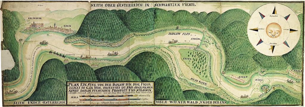
| Keywords: PLAN EIN STICK VON DER DANAW.jpg Darstellung des Donauabschnitts von Greinburg bis St Nikola 1721 kolorierte Handzeichnung object history credit line accession number Sign Kar AB 356 12 http //www onb ac at/sammlungen/karten/kartenzimelien/36 htm Österreichische Nationalbibliothek https //www wau boku ac at/fileadmin/data/H03000/H81000/H81200/_TEMP_/aktuell/Donaubuch_IHG-BOKU_2014 pdf page 160 https //www wau boku ac at/fileadmin/data/H03000/H81000/H81200/_TEMP_/aktuell/Donaubuch_IHG-BOKU_2014 pdf page 161 other versions <gallery> PLAN EIN STICK VON DER DANAW jpg Gesamtkarte Donaustrudel 1721 jpg Kartenausschnitt Donaustrudel Hausstein 1721 jpg Kartenausschnitt Wirbel/Hausstein </gallery> Bild aus einzelnen Bildschirmabzügen zusammengesetzt; Artefakte verringert; Photoshop Speicheroptionen Qualität 12 MagentaGreen PD-old-100 Maps of the upper Danube Wörth Danube Old maps of Austria 1721 maps History of Grein History of Sankt Nikola an der Donau Old maps of the Danube ImageNote 1 1101 284 262 265 1904 672 2 Wörth ImageNoteEnd 1 ImageNote 2 1613 524 83 62 1904 672 2 Hausstein ImageNoteEnd 2 ImageNote 3 145 98 150 95 1904 672 2 Greinburg ImageNoteEnd 3 ImageNote 4 291 133 181 93 1904 672 2 Grein ImageNoteEnd 4 ImageNote 5 1780 419 110 93 1904 672 2 Sankt Nikola an der Donau ImageNoteEnd 5 ImageNote 6 1427 453 131 98 1904 672 2 Struden ImageNoteEnd 6 ImageNote 7 1373 431 50 48 1904 672 2 Burg Werfenstein ImageNoteEnd 7 | ||||