MAKE A MEME
View Large Image
| View Original: | Piri Reis map interpretation.jpg (800x800) | |||
| Download: | Original | Medium | Small | Thumb |
| Courtesy of: | commons.wikimedia.org | More Like This | ||
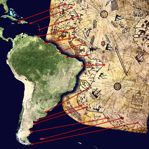
| Keywords: Piri Reis map interpretation.jpg Mögliche Interpretation des Südteils der Karte des Piri Reis Possible interpretation of the Piri Reis map Central and South America on the left North Africa in the upper right south Atlantic Ocean in the middle Markers from north to south Haiti and Dominican Republic Hispaniola island Puerto Rico Lesser Antilles Trinidad and Tobago off the coast of Venezuela Mouth of Corentyne between Guyana and Surinam Amazon Delta River Pará and the island of Marajó far eastern mouth of Amazon river system Easternmost point of South America near Natal Río de la Plata Mouth of Negro River Valdés Peninsula Modern Santa Cruz province in Argentina south of Comodoro Rivadavia Islas Malvinas Cape Horn close to Tierra del Fuego An alternative but less likely interpretation of those ancient map can be found here File Piri Reis map interpretation RG jpg own based on de Datei Karte des piri reis jpg and File Whole world - land and oceans jpg Both sources are public domain 2006-01-10 TMg Note This interpretation is probably incorrect the map only extends 5 degrees south of the equator according to Report No 83-205 SPR The UFO Enigma Marcia S Smith 20 June 1983 Congressional Research Service Appendix B quoting Some trust in chariots sixteen views on Erich von Däniken's Chariots of the gods editors Thiering Barry and Edgar Castle West books 1972 The Piri Reis map also lacks 900 hundred miles of South-American coast and the Drake Passage according to Story Ronald 1980 The Space-gods revealed A close look at the theories of Erich von Däniken 2 ed Barnes Nobles ISBN 0-06-464040-X <gallery> File Piri Reis map interpretation RG jpg Other interpretation </gallery> Maps by Piri Reis Old maps of South America Old maps of Brazil Old maps of Argentina Old maps of Uruguay Old maps of the Río de la Plata | ||||