MAKE A MEME
View Large Image
| View Original: | Piri_Reis_-_Map_of_the_Coastline_from_Piran_as_Far_as_Izola_-_Walters_W658178B_-_Full_Page.jpg (1241x1799) | |||
| Download: | Original | Medium | Small | Thumb |
| Courtesy of: | commons.wikimedia.org | More Like This | ||
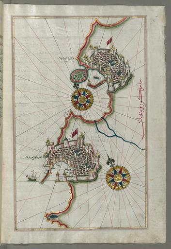
| Keywords: Piri Reis - Map of the Coastline from Piran as Far as Izola - Walters W658178B - Full Page.jpg Piri Reis - Map of the Coastline from Umag as Far as Piran - Walters W658177B - Full Page jpg Piri Reis - Map of the Coastline From Izola as Far as Koper - Walters W658179B - Full Page jpg rtl This folio from Walters manuscript W 658 contains a map of the coastline from Piran Piranu as far as Izola Izele Slovenia late 11th century AH/AD 17th century-early 12th century AH/AD 18th century Ottoman ink and pigments on laid European paper cm 34 24 accession number W 658 178B 79802 Ahmad Afandi date and mode of acquisition unknown see folio 4a Ali Afandi date and mode of acquisiton unknown see folio 4a Sayyid Ali Qapudan date and mode of acquisition unknown see folio 1a Sultan Mahmud Khan date and mode of acquistion unknown waqf seal and followed by a bequest statement now erased and the seal of the inspector of wakfs Mustafá Tahir see folio 4a Henry Walters Baltimore date and mode of acquisition unknown Walters Art Museum Henry Walters Acquired by Henry Walters place of origin Turkey Walters Art Museum license 2D derivative works Piri Reis - Map of the Coastline from Piran as Far as Izola - Walters W658178B - Full Page-edit jpg Piri Reis Kitab-ı Bahriye Walters MS 658 178B Slovenian Riviera 16th-century maps of Slovenia Media contributed by the Walters Art Museum needs category review | ||||