MAKE A MEME
View Large Image

| View Original: | Partage_de_l'Empire_carolingien_au_Traité_de_Verdun_en_843.JPG (3597x3308) | |||
| Download: | Original | Medium | Small | Thumb |
| Courtesy of: | commons.wikimedia.org | More Like This | ||
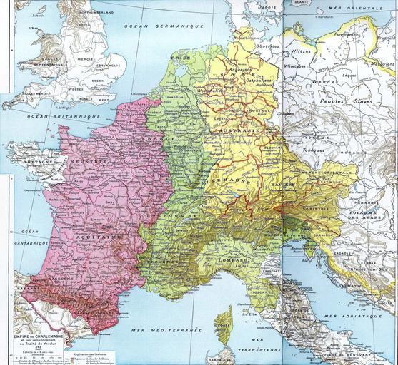
| Keywords: Partage de l'Empire carolingien au Traité de Verdun en 843.JPG Empire de Charlemagne et son démembrement au Traité de Verdun en 843 <br /> En rose Royaume de Charles le Chauve En vert Royaume de Lothaire En jaune Royaume de Louis-le-Germanique The parting of Carolingian Empire by the Treaty of Verdun in 843 <br> Pink area indicates West Francia Green area indicates Middle Francia Yellow area indicates East Francia Histoire Et Géographie - Atlas Général Vidal-Lablache Librairie Armand Colin Paris 1898 Scan made by Olahus PD-old Maps of European history original upload log wikitable date/time username resolution size edit summary ---- 08 40 27 April 2007 User Olahus <a href http //upload wikimedia org/wikipedia/commons/0/0c/Empire_de_Charlemagne_et_son_d C3 A9membrement_au_Trait C3 A9_de_Vermont_843 JPG ><img alt Thumbnail for version as of 08 40 27 April 2007 src http //upload wikimedia org/wikipedia/commons/thumb/0/0c/Empire_de_Charlemagne_et_son_d C3 A9membrement_au_Trait C3 A9_de_Vermont_843 JPG/120px-Empire_de_Charlemagne_et_son_d C3 A9membrement_au_Trait C3 A9_de_Vermont_843 JPG width 120 height 110 border 0 /></a></td><td>3 597×3 308 2 85 MB <nowiki> Empire de Charlemagne et son démembrement au Traité de Vermont 843 Histoire Et Géographie - Atlas Général Vidal-Lablache Librairie Armand Colin Paris 1898 Scan made by <a href /wiki/User Olahus title User Olahus >Olahus</a> Lice</nowiki> Old maps of the history of France 0843 Old maps of Italy 0843 Maps showing history of the Early Middle Ages 0843 Maps showing 9th-century history Maps in French Maps showing history in French Treaty of Verdun Old maps of the Carolingian Empire 0843 Pomerania in the 9th century Paul Vidal de La Blache | ||||