MAKE A MEME
View Large Image
| View Original: | Otago Peninsula from Mount Cargill.jpg (6147x874) | |||
| Download: | Original | Medium | Small | Thumb |
| Courtesy of: | commons.wikimedia.org | More Like This | ||
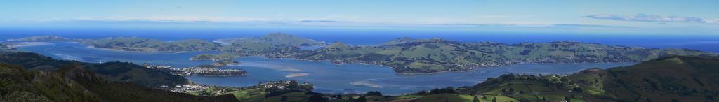
| Keywords: Otago Peninsula from Mount Cargill.jpg Panorama of Otago Peninsula New Zealand taken from Mt Cargill looking southeast across Otago Harbour stitched together with Hugin The mainland is mostly shadowed by clouds field of view approx 90 degrees On the extreme left are the harbour mouth Aramoana and Taiaroa Head Near the centre is Harbour Cone and below it Broad Bay Portobello and Macandrew Bay are to the left and right respectively Quarantine Island is visible in the mid left above Port Chalmers own 2008-12-17 Benchill -45 813307 170 555642 ImageNote 1 46 360 77 77 6147 874 2 Aramoana ImageNoteEnd 1 ImageNote 2 54 307 100 61 6147 874 2 Taiaroa Head ImageNoteEnd 2 ImageNote 3 2843 337 100 100 6147 874 2 Harbour Cone ImageNoteEnd 3 ImageNote 4 2697 468 607 115 6147 874 2 Broad Bay ImageNoteEnd 4 ImageNote 5 2121 429 415 100 6147 874 2 Portobello ImageNoteEnd 5 ImageNote 6 3857 483 1099 146 6147 874 2 Macandrew Bay ImageNoteEnd 6 ImageNote 7 1798 514 254 69 6147 874 2 Quarantine Island ImageNoteEnd 7 ImageNote 8 1222 583 868 92 6147 874 2 Port Chalmers ImageNoteEnd 8 Mount Cargill Otago Harbour Otago Peninsula Panoramics of Dunedin | ||||