MAKE A MEME
View Large Image
| View Original: | Ordnance_Survey_of_Jerusalem_-_The_Survey_was_made_in_the_Years_1864-5_by_Captain_Charles_W._Wilson,_R.E.jpg (2185x2835) | |||
| Download: | Original | Medium | Small | Thumb |
| Courtesy of: | commons.wikimedia.org | More Like This | ||
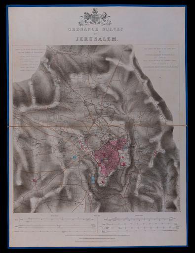
| Keywords: Ordnance Survey of Jerusalem - The Survey was made in the Years 1864-5 by Captain Charles W. Wilson, R.E.jpg ū×ūżūö ū®ū ūÖū©ūĢū®ū ūÖū http //web nli org il/sites/NLI/Hebrew/digitallibrary/Laor-Collection/Pages/maps aspx en Map of Jerusalem Prepared by Charles Wilson as part of the British Ordnance Survey of Jerusalem 1864-5 he ū×ūżū¬ ūÖū©ūĢū®ū ūÖū ū×ūÉū¬ ū”'ū©ū ūĪ ūĢūÖū ūĪūĢū¤ ūöūĢūøūĀūö ūæū×ūĪūÆū©ū¬ ūöūĪū¦ū© ūöūæū©ūÖūśūÖ ū®ū ūÖū©ūĢū®ū ūÖū 1864-5 Dimensions 479x480 mm http //web nli org il/sites/NLI/Hebrew/digitallibrary/pages/viewer aspx presentorid NLI_MAPS_JER DocID NNL_MAPS_JER002368217 Click to enlarge http //web nli org il/sites/NLIS/en/Maps The Eran Laor Cartographic Collection National Library of Israel 2015-12-09 11 23 07 http //web nli org il/sites/NLI/English/Pages/default aspx The National Library of Israel PD-old Old maps of Jerusalem GLAM National Library of Israel Laor collection | ||||