MAKE A MEME
View Large Image
| View Original: | Netherlands,_Zuidland,_map_of_1866.jpg (2549x2074) | |||
| Download: | Original | Medium | Small | Thumb |
| Courtesy of: | commons.wikimedia.org | More Like This | ||
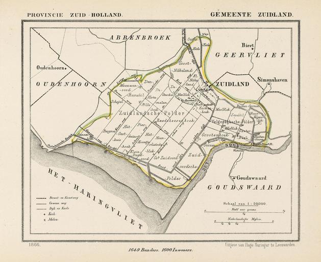
| Keywords: Netherlands, Zuidland, map of 1866.jpg nl Kaart uit 1866 van de voormalige gemeente Zuidland prov Zuid-Holland Deze gemeente bestond ca 168 jaar vanaf het moment dat de gemeente als bestuursvorm werd ingevoerd tot 1 jan 1980 Op die datum fuseerden de gemeenten Zuidland Abbenbroek Geervliet Oudenhoorn en een deel van Heenvliet tot de nieuwe gemeente Bernisse Zuidland ligt ca 18 4 km ten zuidwesten van Rotterdam en Map from 1866 of the former municipality of Zuidland province South Holland Netherlands On January 1st 1980 the municipalities of Zuidland Abbenbroek Geervliet Oudenhoorn and a part of Heenvliet melted together to form the new municipality Bernisse Zuidland lies about 18 4 km southwest of Rotterdam Gemeente-atlas van Nederland naar officieele bronnen bewerkt EN Atlas of Netherlands' municipalities edited after official sources J Kuyper 1866 Published around 1870 as part of a series of provincial atlases of the Netherlands EN This image is in the public domain The author J Kuyper died in 1908 In the Netherlands copyright expires 70 years after the death of the author or 70 years after first publication in the case of anonymous or pseudonymous works or works published by a legal entity NL Dit werk is in het publieke domein De auteur J Kuyper overleed in 1908 Het auteursrecht in Nederland vervalt 70 jaar na de dood van de auteur of 70 jaar na de eerste openbaarmaking van het werk indien het gaat om een anoniem of om een onder pseudoniem verschenen werk of werk van een rechtspersoon The church in Zuidland as indicated with a + on the map is located at 51 49 20 75 N 4 15 35 83 E region NL Maps of Zuidland Gemeente Atlas van Nederland - South Holland Netherlands in the 1860s Old maps of South Holland PD-old-70-1923 | ||||