MAKE A MEME
View Large Image
| View Original: | MontresorNewYorkState1777Detail.jpg (1332x3664) | |||
| Download: | Original | Medium | Small | Thumb |
| Courtesy of: | commons.wikimedia.org | More Like This | ||
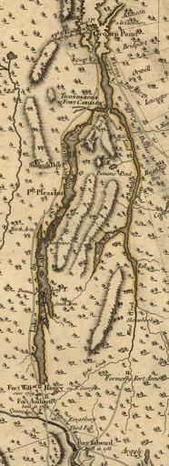
| Keywords: MontresorNewYorkState1777Detail.jpg Detail from a 1777 map showing the area of upstate New York from the upper Hudson River near Fort Edward to Crown Point on Lake Champlain Creator John Montresor Published 1777 by Georges Louis Le Rouge LOC-map g3800 ar106800 Other versions Military maps Old maps of the American Revolution Old maps of New York Lake Champlain Fort Ticonderoga Fort Crown Point John Montresor PD-old-100 | ||||