MAKE A MEME
View Large Image
| View Original: | Map_of_the_San_Joaquin,_Sacramento_and_Tulare_Valleys_1873.jpg (1083x1536) | |||
| Download: | Original | Medium | Small | Thumb |
| Courtesy of: | commons.wikimedia.org | More Like This | ||
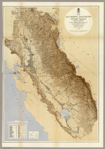
| Keywords: Map of the San Joaquin, Sacramento and Tulare Valleys 1873.jpg Map of San Joaquin Sacramento and Tulare Valleys State of California prepared under the direction of the Board of Commissioners on Irrigation appointed under the Act of Congress approved March 3rd 1873 showing the country that may be irrigated and a provisional system of irrigation Compiled from the Maps of the Geological Survey of California and from Special Survey and Examinations Scale 1 inch to 12 miles 1873 Published by authority of the Hon Secretary of War in the Office of the Chief of Engineers U S Army Gestrichelte Linien mögliche Bewässerungskanäle ---- Map of San Joaquin Sacramento and Tulare Valleys State of California prepared under the direction of the Board of Commissioners on Irrigation appointed under the Act of Congress approved March 3rd 1873 showing the country that may be irrigated and a provisional system of irrigation Compiled from the Maps of the Geological Survey of California and from Special Survey and Examinations 1873 Published by authority of the Hon Secretary of War in the Office of the Chief of Engineers U S Army Scale 1 inch to 12 miles Locality The Central Valley of California ” which includes Sacramento Valley ” Sacramento-San Joaquin River Delta area Metro-Sacramento region and north to the southern Siskiyou Mountains San Joaquin Valley ” south of Sacramento-San Joaquin River Delta and Metro region to the Tehachapi Mountains Tulare Valley ” older term for the Tulare Basin of the lower San Joaquin Valley showing former Tulare Lake Dotted lines hypothetical irrigation canals The Sierra Nevada are on the east right http //www davidrumsey com/ David Rumsey Map Collection “ Cartography Associates 1873 Board of Commissioners on Irrigation California <gallery>file Map of the San Joaquin Sacramento and Tulare Valleys 1873 - Tulare Valley jpg Tulare Valley part</gallery> PD-old 1873 maps California in the 1870s Central Valley of California 02 Sacramento “San Joaquin River Delta 1870 Maps of the history of California Maps of Sacramento California San Joaquin Sacramento and Tulare Valleys 1873 Old maps of California 1870s San Joaquin Valley 02 Sierra Nevada United States 04 | ||||