MAKE A MEME
View Large Image
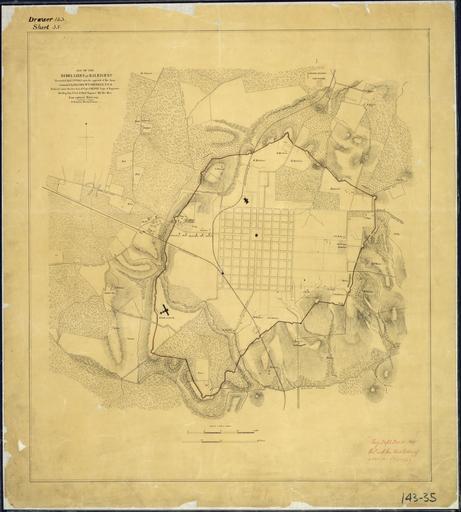
| View Original: | Map_of_the_Rebel_Lines_at_Raleigh,_N.C.,_Evacuated_April_13th,_1865,_upon_the_approach_of_the_Army_commanded_by_Maj...._-_NARA_-_305783.jpg (5400x6000) | |||
| Download: | Original | Medium | Small | Thumb |
| Courtesy of: | commons.wikimedia.org | More Like This | ||
| Keywords: Map of the Rebel Lines at Raleigh, N.C., Evacuated April 13th, 1865, upon the approach of the Army commanded by Maj.... - NARA - 305783.jpg Scope and content General notes 305783 Local identifier 77-FORTS-DR143SHT35 War Department Office of the Chief of Engineers 1818 - 09/18/1947 Cartographic and Architectural Records Section Special Media Archives Services Division NWCS-C National Archives at College Park 8601 Adelphi Road College Park MD 20740-6001 ca date 1865 12 04 Record group Record Group 77 Records of the Office of the Chief of Engineers 1789 - 1999 Record group ARC 406 Fortifications Map File Plans of Military Forts compiled 1790 - 1941 Series ARC 305749 File unit File unit ARC Variant control numbers NAIL Control Number NWDNC-77-FORTS-DR143SHT35 Other versions <gallery> File Map_of_the_Rebel_Lines_at_Raleigh _N C _Evacuated_April_13th _1865 _upon_the_approach_of_the_Army_commanded_by_Maj _-_NARA_-_305783 tif tif File Map_of_the_Rebel_Lines_at_Raleigh _N C _Evacuated_April_13th _1865 _upon_the_approach_of_the_Army_commanded_by_Maj _-_NARA_-_305783 jpg jpg </gallery> NARA-cooperation PD-USGov Maps of Raleigh North Carolina Old maps of North Carolina in the American Civil War 1865 maps April 1865 | ||||