MAKE A MEME
View Large Image

| View Original: | Map_of_the_early_settlements_of_Delaware_County,_Penna.jpg (5495x4397) | |||
| Download: | Original | Medium | Small | Thumb |
| Courtesy of: | commons.wikimedia.org | More Like This | ||
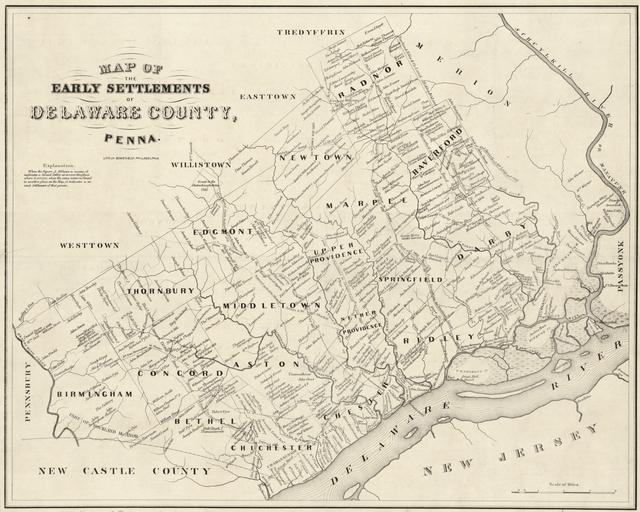
| Keywords: Map of the early settlements of Delaware County, Penna.jpg en Map of the early settlements of Delaware County Pennsylvania Published 1862 but shows landholdings c 1790 when Delaware County separated from Chester County Library of Congress Metadata follows Title Map of the early settlements of Delaware County Penna Contributor Names Smith George 1804-1882 Ashmead Henry Buckley Bowen Co Created / Published Philadelphia H B Ashmead 1862 Subject Headings - Landowners--Pennsylvania--Delaware County--Maps - Delaware County Pa --Administrative and political divisions--Maps - United States--Pennsylvania--Delaware county Genre Maps Notes - Shows landholders' names and townships ca 1790 as after the separation of Delaware County from Chester County in 1789 Does not show boundary lines of real-property tracts - Removed from textual publication Smith George 1804-1882 History of Delaware County Pennsylvania 1862 LC classification F157 D3 S6 - Originally designed to fold to 23 x 13 cm - Available also through the Library of Congress Web site as a raster image - LC copy imperfect Annotated in lead pencil in lower margin to give name of the original publication - LC copy accompanied by negative photostat copy - Includes note - LC Land ownership maps 739 Medium 1 map cloth backing ; 36 x 45 cm Call Number G3823 D4G46 1790 S6 Repository Library of Congress Geography and Map Division Washington D C 20540-4650 USA dcu Digital Id http //hdl loc gov/loc gmd/g3823d la000739 Library of Congress Catalog Number 2012593312 1862 http //www loc gov/item/2012593312/ Smith George author Ashmead Henry Buckley publisher Bowen Co printer other versions PD-old-70-1923 Delaware County Pennsylvania Uploaded with UploadWizard | ||||