MAKE A MEME
View Large Image

| View Original: | Map after Ptolemy's Geographia (Burney MS 111, f.28v).jpeg.jpg (5207x6887) | |||
| Download: | Original | Medium | Small | Thumb |
| Courtesy of: | commons.wikimedia.org | More Like This | ||
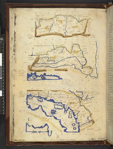
| Keywords: Map after Ptolemy's Geographia (Burney MS 111, f.28v).jpeg Rhaetia Vindelicia et Noricum atque Pannonia superior et inferiorque atque Illyria The Fifth European Map in three parts from a Greek manuscript edition of Ptolemy's Geography depicting the Roman Alpine provinces Upper and Lower Pannonia Illyria Liburnia and Dalmatia ß┐¼╬▒╬╣Žä╬É╬▒Žé ╬║╬▒╬╣ ßĮłŽģ╬╣╬Į╬┤╬Ą╬╗╬║╬É╬▒Žé ╬ś╬ŁŽā╬╣ŽéĀ/ ╬Ā╬▒╬Į╬Į╬┐╬ĮŽŖß┐Č╬Į ╬ö╬░╬┐ Žäß┐åŽé ß╝ī╬ĮŽē ╬║ßĮ░╬╣ ╬Ü╬¼ŽäŽē ╬ś╬ŁŽā╬╣ŽéĀ/ ß╝Ė╬╗╬╗ŽģŽü╬»╬┤╬┐Žé ßĮÆ ╬ø╬╣╬▓╬┐ŽģŽü╬Į╬É╬▒Žé ß╝Ā ╬ö╬▒╬╗╬╝╬▒Žä╬É╬▒Žé ╬ś╬ŁŽā╬╣Žé ß┐¼╬▒╬╣ŽäŽŖ╬▒ ßĮłŽģŽŖ╬Į╬┤╬Ą╬╗╬║╬É╬▒ ╬ ŽēŽüŽŖ╬║╬┐╬Į ╬Ā╬▒╬Į╬Į╬┐╬Į╬»╬▒ ß╝Ī ╬ō╬╣╬│╬▒Žé ╬║╬▒╬╣ ß╝Ī ╬Ü╬¼ŽäŽē ╬║╬▒╬╣ ߊĮ╬¬╬╗╬╗ŽģŽü╬»Žé Institution British Library map date other fields Information field British Library Shelfmark Burney MS 111 f 28v other versions PD-old print date British Library image ark /81055/vdc_100000001311 0x0000a6 A collection of maps in Greek after Ptolemy's Geography warp status wikidata location wikidata title Uploaded with GWToolset Map after Ptolemy's Geographia Burney MS 111 f 28v http //www webarchive org uk/bldatasets/MapImages/Pelagios/PtolemyGeography/burney_ms_111_f028v jpeg British Library Maps Collections Burney MS 111 028 Maps in Greek 1420 maps Ptolemy's 5th European Map 1420 ImageNote 1 3138 4645 379 207 5207 6887 2 ߊĮŽŖ╬╗╬╗ŽģŽü╬»Žé<br>Illyr├Łs ImageNoteEnd 1 ImageNote 2 2563 908 345 218 5207 6887 2 ßĮ ŽģŽŖ╬Į╬┤╬Ą╬╗╬║╬É╬▒<br>Ou├»delk├»a ImageNoteEnd 2 ImageNote 3 3322 1150 299 172 5207 6887 2 ╬ĮŽēŽüŽŖ╬║╬┐╬Į<br>N┼Źrikon ImageNoteEnd 3 ImageNote 4 2046 1196 276 207 5207 6887 2 ß┐ż╬▒╬╣ŽäŽŖ╬▒<br>Rhait├»a ImageNoteEnd 4 ImageNote 5 2264 2541 402 241 5207 6887 2 Ž ╬▒╬Į╬Į╬┐╬Į╬»╬▒ ß╝Ī ╬│╬╣╬│╬▒Žé <br> Pannon├Ła h─ō Gigas ImageNoteEnd 5 ImageNote 6 3368 2299 264 207 5207 6887 2 Ž ╬▒╬Į╬Į╬┐╬Į╬»╬▒ ß╝Ī ╬║╬¼ŽäŽē <br> Pannon├Ła h─ō K├Īt┼Ź ImageNoteEnd 6 ImageNote 7 2172 402 1678 207 5207 6887 2 ß┐ź╬▒╬╣Žä╬É╬▒Žé ╬║╬▒╬╣ ßĮ Žģ╬╣╬Į╬┤╬Ą╬╗╬║╬É╬▒Žé ╬Ė╬ŁŽā╬╣Žé <br> Rhait├Łas kai Ouindelk├Łas Th├®sis ImageNoteEnd 7 ImageNote 8 1506 1840 2379 138 5207 6887 2 Ž ╬▒╬Į╬Į╬┐╬ĮŽŖß┐Č╬Į ╬┤╬░╬┐ Žäß┐åŽé ß╝ä╬ĮŽē ╬║ßĮ░╬╣ ╬║╬¼ŽäŽē ╬Ė╬ŁŽā╬╣Žé <br> Pannon├»┼Źn D├║o t─ōs An┼Ź k├Āi K├Īt┼Ź Th├®sis ImageNoteEnd 8 ImageNote 9 1609 3898 2471 126 5207 6887 2 ß╝░╬╗╬╗ŽģŽü╬»╬┤╬┐Žé ßĮÆ ╬╗╬╣╬▓╬┐ŽģŽü╬Į╬É╬▒Žé ß╝Ā ╬┤╬▒╬╗╬╝╬▒Žä╬É╬▒Žé ╬Ė╬ŁŽā╬╣Žé <br> Illyr├Łdos y Libourn├Łas h─ō Dalmat├Łas Th├®sis ImageNoteEnd 9 | ||||