MAKE A MEME
View Large Image
| View Original: | Mahan Problem of Asia 1900.png (1357x353) | |||
| Download: | Original | Medium | Small | Thumb |
| Courtesy of: | commons.wikimedia.org | More Like This | ||
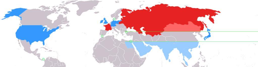
| Keywords: Mahan Problem of Asia 1900.png This map depicts the world as divided by geostrategist Alfred Thayer Mahan in his 1900 piece The Problem of Asia Asia is divided along the 30 north and 40 north parallels represented here by green lines Colored in red are the two allied land powers the Russian Empire and France In lighter red are the portions of Asia above the 40th parallel under effective influence of Russian land power Colored in blue are the four allied sea powers Great Britain the German Empire Japan and the United States In lighter blue are the portions of Asia below the 30th parallel subject to effective control by sea power In between the 30th and 40th parallel is what Mahan termed the Debatable and debated ground subject to competition between the land powers and sea powers Circled in green are key isthmuses identified by Mahan the Suez Canal Panama Canal Dardanelles Straits of Gibraltar and Baltic Straits Source Created by myself user Perceval using the Image BlankMap-World-WWI PNG en wikipedia 2006-12-22 Perceval wikipedia en Perceval Original upload log en wikipedia Mahan+Problem+of+Asia+1900 png wikitable - 2006-12-22 04 06 1357×353× 27252 bytes Perceval <nowiki>This map depicts the world as divided by geostrategist Alfred Thayer Mahan in his 1900 piece The Problem of Asia Asia is divided along the 30 north and 40 north parallels represented here by green lines Co</nowiki> Blank maps of the world for historical use | ||||