MAKE A MEME
View Large Image

| View Original: | MA Norfolk (old) Co towns map.png (947x1380) | |||
| Download: | Original | Medium | Small | Thumb |
| Courtesy of: | commons.wikimedia.org | More Like This | ||
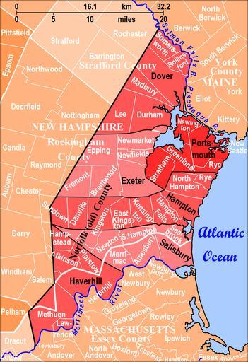
| Keywords: MA Norfolk (old) Co towns map.png en Norfolk County in Massachusetts and New Hampshire created in 1643 part of Massachusetts Bay Colony had six towns shown in red and black These six towns are overlaid on a map of present-day Essex County in Massachusetts Rockingham County in New Hampshire Strafford County in New Hampshire and surrounding towns with borders in white 2012-07-13 own Diltsgd Source http //www familysearch org/learn/wiki/en/File MA_Norfolk_ old _Co_towns_map png File MA_Norfolk_ old _Co_towns_map png at FamilySearch Research Wiki accessed 22 October 2012 Based on 1 Map of Old Norfolk County 1643 found on the page between 18 and 19 in Old Norfolk County Records Essex Antiquarian 1 no 2 February 1897 19 http //books google com/books id Wg4XAAAAYAAJ pg PA19 v onepage q f false Google Books 2 the list of modern towns cited on page 19 of the previous source 3 Michael J Leclerc Genealogist's Handbook for New England Research 5th ed Boston Mass New England Historic Genealogical Society 2012 254 and 4 Karl Musser File Merrimackrivermap png in Wikimedia Commons at http //commons wikimedia org/wiki/File Merrimackrivermap png accessed 3 July 2012 cc-zero Uploaded with UploadWizard Massachusetts Bay Company | ||||