MAKE A MEME
View Large Image
| View Original: | LB_and_SCRly_map_204.jpg (1500x1972) | |||
| Download: | Original | Medium | Small | Thumb |
| Courtesy of: | commons.wikimedia.org | More Like This | ||
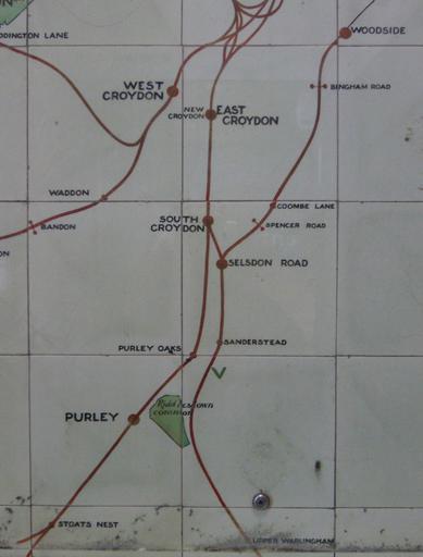
| Keywords: LB and SCRly map 204.jpg 300px right Part of a map of the suburban lines of the London Brighton and South Coast Railway made in ceramic tiles and on display at Victoria Station It dates from after 1905 because Bandon Halt station opened in 1906 and from before 1911 because it shows http //www subbrit org uk/sb-sites/stations/c/coulsdon_north/index shtml Stoats Nest station which was renamed in that year At the centre of the image on the right is a station entrance Go in there and look to your left You will see a ceramic map of the whole of the LB SCR network A few steps further on and also on the left is this map Some of you have walked past it many times and never seen it The http //rhaworth ucoz net/tq/th/072203 jpg map key describes Bingham Road Spencer Road and Bandon as motor halts The green 'V' below Sanderstead marks a golf club presumably Purley Downs GC The silver object near the bottom is the head of a screw which is holding a protective perspex sheet in place PD-Art but for the ruling cited above I would licence this as my own work with Roger W Haworth's licence Signs in London Victoria station Rail transport maps of the United Kingdom Maps of the London Borough of Croydon Rail transport in the London Borough of Croydon Ceramics in the City of Westminster Artworks missing infobox template | ||||