MAKE A MEME
View Large Image

| View Original: | LA2-Rivers of western Russia.png (1274x1178) | |||
| Download: | Original | Medium | Small | Thumb |
| Courtesy of: | commons.wikimedia.org | More Like This | ||
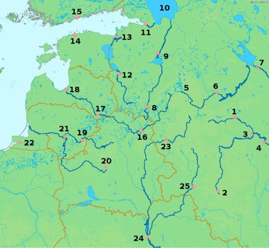
| Keywords: LA2-Rivers of western Russia.png Map of western Russia with national borders marked brown rivers emphasized dark blue and major cities pink numbered black Bounding box West 19° South 50° East 40° North 61° Center at 55 50000 N 29 50000 E scale 6600000 Based on a public domain map from the Demis map server Markup added by LA2 2008-05-21 LA2 PD-Demis river volkhov localization map jpg daugava western dvina map jpg Legend Moscow 1 is situated on the Moskva River which at Kolomna 3 joins the Oka River coming from Oryol 2 and continuing west to Ryazan 4 Europe's longest river the Volga originates in the Valdai Hills 5 passes Tver 6 and Rybinsk 7 Both the Oka and the Volga continue east beyond this map The River Lovat originates in northern Belarus passes Velikiye Luki 8 on its way to lake Ilmen Further north the Volkhov River passes the town Veliky Novogorod 9 en route to Europe's largest lake Lake Ladoga 10 From there the short Neva River passes Saint Petersburg 11 at the Gulf of Finland The Velikaya River passes Pskov 12 at Lake Peipus from where the short Narva River passes through the town of Narva 13 near the Gulf of Finland The capitals of Estonia Tallinn 14 and of Finland Helsinki 15 guard the gulf on opposite sides Daugava is the Latvian name of the Zapadnaya Dvina which passes Vitebsk 16 Daugavpils 17 and ends at Riga 18 at the Gulf of Riga The Neris which passes through Lithuania's capital Vilnius 19 is a tributary of the Neman River which originates near Minsk 20 the capital of Belarus The two merge at Kaunas 21 The Neman ends at the Curian Lagoon Further south is the city of Kaliningrad/Königsberg 22 on the Pregolya River which empties into the Vistula Lagoon The long Dnieper River passes Smolensk 23 in Russia runs through Belarus and Kiev 24 in Ukraine before it finally empties into the Black Sea One of its tributaries is the Desna River which passes Bryansk 25 Lovat River Maps of rivers of European part of Russia Diagrams labelled with numbers only Maps of the Gulf of Riga | ||||