MAKE A MEME
View Large Image
| View Original: | KAARTEN SGD - Waterkwaliteitsplan Noordzee.jpeg (1084x1581) | |||
| Download: | Original | Medium | Small | Thumb |
| Courtesy of: | commons.wikimedia.org | More Like This | ||
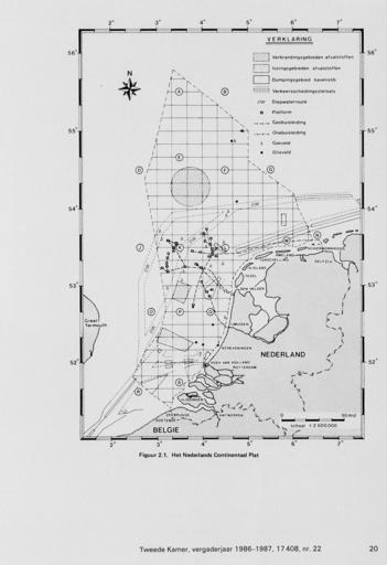
| Keywords: KAARTEN SGD - Waterkwaliteitsplan Noordzee.jpeg accession number en The individual creators of this map are unknown it was commissioned by the House of Representatives of the Netherlands Met overzichts- en detailkaarten die mogelijke vestingsplaatsen voor mogelijke kerncentrales aanduiden op de plaatsen Wieringermeer Bergumermeer Borssele Boxmeer Eems Flevo noord Ketelmeer Maasvlakte Maas-Waal Markerwaard/Houtribdijk Moerdijk help warp This map was digitized by the Institution Koninklijke Bibliotheek ; Koninklijke Bibliotheek 52 1666666666667 Noordzee 5 29166666666667 map date 1986 ruimtelijke planning concentratie in zeewater aanwezige chemische stoffen other fields other versions CC0 print date 1986 This map was commissioned and published by the Institution Tweede Kamer Diverse schalen This image in context http //www statengeneraaldigitaal nl/document id sgd mpeg21 19861987 0002273 pagina 20; Tweede Kamer KAARTEN SGD - Waterkwaliteitsplan Noordzee wikidata location wikidata title Uploaded with GWToolset KAARTEN SGD - Waterkwaliteitsplan Noordzee http //resolver kb nl/resolve urn sgd mpeg21 19861987 0002273 0020 image Maps of the North Sea | ||||