MAKE A MEME
View Large Image
| View Original: | KAARTEN SGD - Nieuwe groepering van landbouwgebieden in Nederland in 14 groepen.jpeg (1162x1606) | |||
| Download: | Original | Medium | Small | Thumb |
| Courtesy of: | commons.wikimedia.org | More Like This | ||
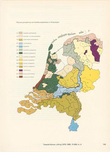
| Keywords: KAARTEN SGD - Nieuwe groepering van landbouwgebieden in Nederland in 14 groepen.jpeg accession number en The individual creators of this map are unknown it was commissioned by the House of Representatives of the Netherlands Behoort bij bijlage E van het wetsontwerp Vervreemding landbouwgronden help warp This map was digitized by the Institution Koninklijke Bibliotheek ; Koninklijke Bibliotheek 52 1666666666667 Nederland 5 29166666666667 map date 1980 agrarische regio's other fields other versions CC0 print date 1980 This map was commissioned and published by the Institution Tweede Kamer ca 1 1 750 000 This image in context http //www statengeneraaldigitaal nl/document id sgd mpeg21 19791980 0006661 pagina 143; Tweede Kamer KAARTEN SGD - Nieuwe groepering van landbouwgebieden in Nederland in 14 groepen wikidata location wikidata title Uploaded with GWToolset KAARTEN SGD - Nieuwe groepering van landbouwgebieden in Nederland in 14 groepen http //resolver kb nl/resolve urn sgd mpeg21 19791980 0006661 0143 image | ||||