MAKE A MEME
View Large Image
| View Original: | IRplannedmap.png (1284x2929) | |||
| Download: | Original | Medium | Small | Thumb |
| Courtesy of: | commons.wikimedia.org | More Like This | ||
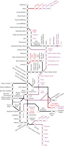
| Keywords: IRplannedmap.png Israel Railways map for the follow-up expansion plan In black are existing lines and stations in red are lines and stations under construction or advanced planning In purple are approved lines and stations the gray part being an extension to Jordan References http //port2port co il/Index asp ArticleID 68668 CategoryID 46 Year 2010 Month 7 Page 1 Eastern Line http //www rail co il/HE/Development/Pages/ū×ūżū¬ū¬ūĢūøūĀūÖū¬ūöūżūÖū¬ūĢūŚ aspx Israel Railways official development map http //www modiin muni il/ModiinWebSite/ChannelArticleNews aspx PageID 2_295 id 2158 Modi'in Arc http //www iroads co il/content/ū×ūĪūÖū ū¬-ūæūÉū©-ū®ūæūó-ūóū©ūō Railway to Arad http //www yediot co il/articles/0 7340 L-4830121 00 html Railway to Kiryat Shmona Own 2008-04-04 Ynhockey Israel Railways maps | ||||