MAKE A MEME
View Large Image
| View Original: | Hindutash_in_Kashmir.jpg (383x559) | |||
| Download: | Original | Medium | Small | Thumb |
| Courtesy of: | commons.wikimedia.org | More Like This | ||
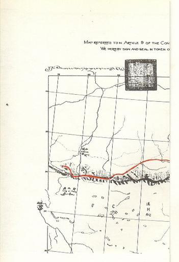
| Keywords: Hindutash in Kashmir.jpg en Extract from the Map referred to in Article 9 of the Simla Convention between Great Britain China and Tibet dated the 5th July 1914 depicting the southern border of Khotan and East Turkistan with Kashmir on the Kuen Lun range in the area of Hindutash in Kashmir as a red line The map was initialed by the British representative and signed by the Tibetan and Chinese representatives The latter two did not merely initial the Convention but signed it The source or creator is the Government of U K of that relevant period of time July 3 1914 The map is reproduced in all note worthy books dealing with India ™s border issue including Himalayan Frontiers by Dorothy Woodman published inter alia by London Barrie and Rockliff The Cresset Press 1969 The map attached to the Simla Convention July 3 1914 2009-02-04 own PD-art Original upload log en wikipedia ftcg page en wikipedia Hindutash_in_Kashmir jpg wikitable - 07 55 18 February 2009 383 Ă— 559 76 621 bytes Hindutashravi w en <nowiki>Extract from the Map referred to in Article 9 of the Simla Convention between Great Britain China and Tibet dated the 5th July 1914 depicting the southern border of Khotan and East Turkistan with Kashmir on the Kuen Lun range in the area of Hindutash in</nowiki> Maps of Tibet Seals of Tibet Simla Convention | ||||