MAKE A MEME
View Large Image

| View Original: | Georg_Friedrich_Dinglinger_Aug._Vind_MatthûÊus_Seutter_Tobias_Conrad_Lotter_Hannover_Aegidienneustadt_um_1750.jpg (1477x1303) | |||
| Download: | Original | Medium | Small | Thumb |
| Courtesy of: | commons.wikimedia.org | More Like This | ||
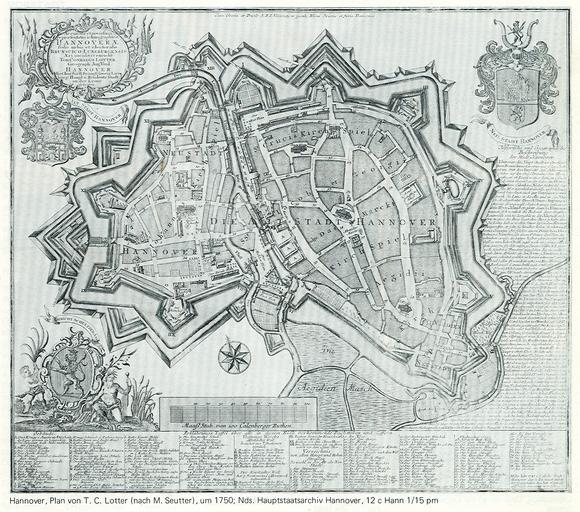
| Keywords: Georg Friedrich Dinglinger Aug. Vind MatthûÊus Seutter Tobias Conrad Lotter Hannover Aegidienneustadt um 1750.jpg en Map of of the cities of Hanover with the new builded Aegidienneustadt in the south-east and Calenberger Neustadt de Um 1750 Plan der mit einer gemeinsamen Verteidigungsanlage umschlossenen Calenberger Neustadt westlich des Leine-Flusses und Hannover ûÑstlich der Leine im Sû¥dwesten auf einer ehemaligen Bastion die Aegidienneustadt Scan of a little copy in the book Denkmaltopographie Bundesrepublik Deutschland Baudenkmale in Niedersachsen Stadt Hannover Teil 1 Band 10 1 Seite 63 Kupferstecher Tobias Conrad Lotter nach MatthûÊus Seutter nach Georg Friedrich Dinglinger; Geograph Aug Vind; ~ 1750 52ô¯ 22 ý N 9ô¯ 44 ý O PD-old Copper engravings Engravings of Hannover 1750s about Old maps of Hannover 175Os about Maps by Seutter Tobias Lotter Georg Friedrich Dinglinger Master Builder Hannover in the 1750s 18th-century engravings 1750s about 1740s works in Germany 1750s works in Germany | ||||