MAKE A MEME
View Large Image
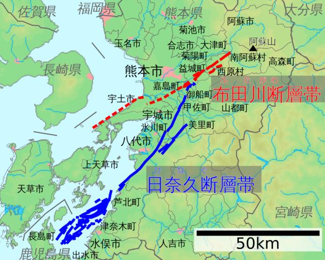
| View Original: | Futagawa-Hinagu Fault Zone map ja.svg (1000x800) | |||
| Download: | Original | Medium | Small | Thumb |
| Courtesy of: | commons.wikimedia.org | More Like This | ||
| Keywords: Futagawa-Hinagu Fault Zone map ja.svg ÕĖāńö░ÕĘ Ńā╗µŚźÕźłõ╣ģµ¢ŁÕ▒żÕĖ»Ńü«Õ ░Õø│Ń üµŚźµ ¼Ķ¬×ńēłŃ é en A map of Futagawa-Hinagu Fault Zone in Kyushu Japan in Japanese language 2016-04-17 Elevation rivers coastline city area’╝łµ©Öķ½śŃ üµ▓│ÕĘ Ń üµĄĘÕ▓ĖńĘÜŃ üÕĖéĶĪŚÕ ░’╝ē Public domain map from screenshot of http //www demis nl Cities and Prefectures area’╝łÕĖéń īÕóā’╝ē GFDL and CC-BY-SA-3 0 map from File Map_of_Oita_Prefecture_Ja svg and File Map_of_Kumamoto_Prefecture_Ja svg Faults’╝łµ¢ŁÕ▒ż’╝ē Traced from a report of The Headquarters For Earthquake Research Promotion’╝łhttp //www jishin go jp Õ ░ķ ćĶ¬┐µ¤╗Õ¦öÕōĪõ╝Ü Ń īhttp //www jishin go jp/main/yosokuchizu/katsudanso/f093_futagawa_hinagu htm ÕĖāńö░ÕĘ µ¢ŁÕ▒żÕĖ»Ńā╗µŚźÕźłõ╣ģµ¢ŁÕ▒żÕĖ»Ńü«Ķ®ĢõŠĪ’╝łõĖ ķā©µö╣Ķ©é’╝ē Õø│2Ń Ź’╝ē 2013 Elevation rivers coastline city area Pekachu Cities and Prefectures area original by ja Õł®ńö©Ķ ģ Lincun modified by Pekachu Faults original by The Headquarters For Earthquake Research Promotion’╝łÕ ░ķ ćĶ¬┐µ¤╗Õ¦öÕōĪõ╝Ü’╝ē traced by Pekachu other versions Custom license marker 2016 04 17 PD-Demis GFDL relicense Faults in Japan Geography of Kumamoto prefecture 2016 Kumamoto earthquake | ||||