MAKE A MEME
View Large Image
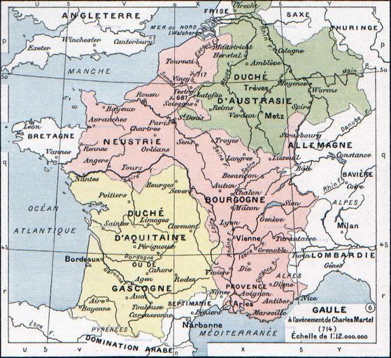
| View Original: | Francia_at_the_death_of_Pepin_of_Heristal,_714.jpg (1254x1149) | |||
| Download: | Original | Medium | Small | Thumb |
| Courtesy of: | commons.wikimedia.org | More Like This | ||
| Keywords: Francia at the death of Pepin of Heristal, 714.jpg This is a straightened and color balanced crop of a scan of a map from Paul Vidal de la Blache's Atlas général d'histoire et de géographie 1912 Gaule à l'avènement de Charles Martel 714 Paul Vidal de La Blache Atlas général d'histoire et de géographie 1912 Paul Vidal de la Blache's Atlas général d'histoire et de géographie 1912 The original scanned image can be found at http //www hipkiss org/data/maps/vidal-lablache_atlas-general-histoire-et-geographie_1912_ancient-gaul-merovian-merovingienne_2953_4252_600 jpg Information on the original scan can be found at http //www hipkiss org/cgi-bin/maps pl book Vidal 20Lablache 20- 20Atlas 20General 20Histoire 20Et 20Geographie 1912 Creator Paul Vidal de la Blache PD-old-auto-1923 1918 page is/was here All following user names refer to en wikipedia 2007-08-19 21 33 Srnec 1241×1136×8 353954 bytes <nowiki>The map comes from Vidal-Lablache Atlas général d'histoire et de géographie 1894 PD-art-life-70 </nowiki> 2007-09-10 16 34 Earthsound 1254 × 1149×8 1 MB <nowiki>Gaule at the time of Charles Martel 714 The scale is 1 12 000 000 This is a straightened and color balanced crop of a scan of a map from Paul Vidal de la Blache's 'Atlas général d'histoire et de géograp PD-art-life-70 </nowiki> Charles Martel Maps of the Merovingian territory Maps of Gauls France in the 8th century Paul Vidal de La Blache | ||||