MAKE A MEME
View Large Image
| View Original: | FMIB_48255_Chart_of_Harbor_Island_and_Chain_Shot_Shoal_at_the_Junction_of_Pamlico_and_Core_Sounds,_showing_the_location_of_planted_beds.jpeg (877x856) | |||
| Download: | Original | Medium | Small | Thumb |
| Courtesy of: | commons.wikimedia.org | More Like This | ||
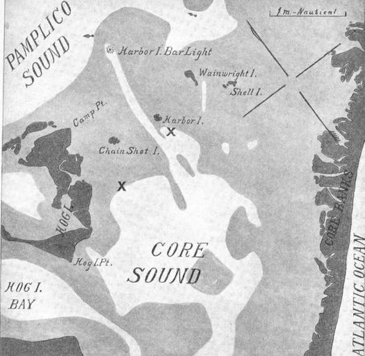
| Keywords: FMIB 48255 Chart of Harbor Island and Chain Shot Shoal at the Junction of Pamlico and Core Sounds, showing the location of planted beds.jpeg check categories 28 August 2015 3 Chart of Harbor Island and Chain Shot Shoal at the Junction of Pamlico and Core Sounds showing the location of planted beds Water less than 6 feet in depth is indicated by light shading; over 6 feet undhaded Oysster plants are indicated by X marks Subject Oyster culture--North Carolina Harbor Island North Carolina --Maps Geographic Subject United States--North Carolina--Harbor Island Tag Shellfish 1907 Cite book Experiments in Oyster Culture in Pamlico Sound North Carolina Coker Robert E Raleigh NC E M Uzzell Co 1907 Bulletin North Carolina Geological and Economic Survey ; no 15 Fig 1 Creator Robert Ervin Coker PD-UWASH-FMIB Institution University of Washington FMIB-source accession number 48255 Images from the Freshwater and Marine Image Bank to check Robert Ervin Coker Shellfish Harbor Island Seattle Washington | ||||