MAKE A MEME
View Large Image
| View Original: | Estuarine_and_coastal_drainage_regions_for_Alaska_USGS.jpg (575x445) | |||
| Download: | Original | Medium | Small | Thumb |
| Courtesy of: | commons.wikimedia.org | More Like This | ||
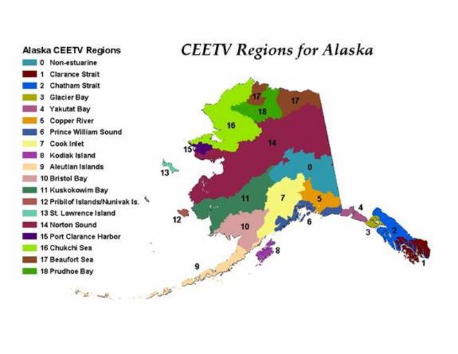
| Keywords: Estuarine and coastal drainage regions for Alaska USGS.jpg adapted from the USGS website Estuarine Drainage Area and Coastal Drainage Area are hydrologic units based on watershed boundaries The terms were defined and developed as part of the Coastal Assessment Framework CAF of the National Ocean Service within the National Oceanographic and Atmospheric Administration NOAA For detailed definitions and explanations of these terms visit the CAF website at http //coastalgeospatial noaa gov/back_gis html NOAA has yet to define Estuarine and Coastal Drainage Areas for Alaska Regions for Alaska as shown here were delineated based on topography and existing hydrologic unit codes HUCs The notation CEETV refers to the Contaminant Exposure and Effects-Terrestrial Vertebrates Database for which this map was created Uploader notes that region 18 apparently representing the Colville River area and designated Prudhoe Bay does not actually drain into Prudhoe Bay See File Alaska level 6 hydrologic units jpg File NPRA F1lg gif and File Alaska Public Lands Map4000x2255 png Undated; website last updated 5-02-2012 http //www pwrc usgs gov/ceetv/estuary htm USGS Patuxent Wildlife Research Center PD-USGov Uploaded with UploadWizard Regions of Alaska Hydrology in the United States Watersheds of Alaska | ||||